In an earlier post, we described and illustrated what the flooded Altamaha was like on our Georgia Conservancy paddle trip. This post will take you down the river and through the marshes to Darien. Remember the water is still up.
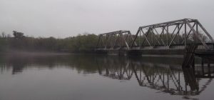
We left camp headed for Darien, with most of us leaving our gear up to dry knowing that we’d be shuttled back to camp to pick up cars and belongings. On the water, we passed under the abandoned bridge that had threatened to be a boat magnet on the day before. Once we were safely downstream from the bridge our expert leaders from the Georgia Paddlers Association and the Georgia Conservancy gathered us up for the paddle to Darien.
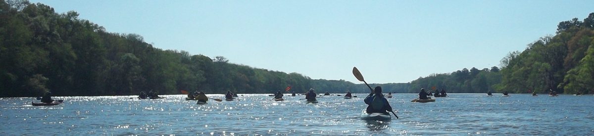
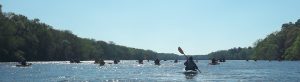
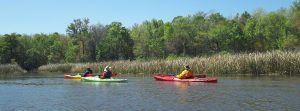
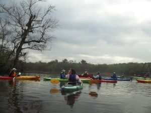
The Altamaha is a big river and on our day on the river it was moving fast so we could easily spread out to an unmanageable degree. To prevent this, the lead boat stopped our forward progress occasionally, however the few stops did little to dampen the enthusiasm of the group
Experienced paddlers and novices both found their stroke and let the mighty river roll them along. Of course, the Altamaha doesn’t actually flow through Darien so one of the concerns of the leaders was making sure that the flotilla didn’t lose any members because they missed the cut off into the creek. The creek, Stud Horse Creek, had a great name and served to provide passage over to Lewis Creek.
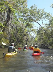
The creek wasn’t that small but if you didn’t know where to turn you would certainly have a problem. We all made it safely down the Altamaha to the creek where one of our safety guides was paddling in place and pointing us in the direction to go. A mile or too into the creek and you began to realize the diversity of the lowland river. We had seen the wide Altamaha with the water out of the banks and now we entered an area of reeds and water grass. A place where we keep a sharp eye for alligators but saw none. You’ll have to wait for the post on the Georgia Conservancy trip to the Okefenoke to hear the alligator stories.
The Altamaha and the river system around it was once a bustling timber industry river route with log rafts built upstream and floated down the river to Darien. Someone decided that the winding river channels weren’t meant for that so, before the Civil War, slave labor was used to build a canal. Our venture through Stud Horse Creek served to put us in position to re-enter the Altamaha just upstream of the Rifle Cut.
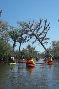
This hand dug canal stretches for a mile across the lowlands and provided us with a short-cut to Darien. Called the “rifle cut” because of its straightness, it is now only a curiosity. The canal doesn’t seem large enough to have been able to handle rafts of logs and indeed the thinking was that erosion would make the canal larger and therefore useable. It didn’t happen. However, because you are in the low lands near the ocean you do need to know about your tides because the water in the rifle cut is greatly influenced by the tide and you might find yourself paddling a little harder than you anticipated if you judge the tides incorrectly. You don’t really want to paddle against the tide for a mile.
You probably know that the trees along the banks of a body of water such a river or stream lend to lean over the channel, but that seemed extreme as we were going through the rifle cut. As you see in the next picture some of these trees seem to have defying gravity for quite a while.
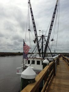
The rifle cut takes you into the Darien River above its confluence with Cathead Creek and on the west side of I-95. It is a bit disconcerting to arrive back at civilization coming under a concrete and steel overpass where thousands of cars pass every day, with almost none of their occupants ever getting the chance to see what we got to see on this trip to Darien. Of course, the trip had to end so we pulled our kayaks up to the boat ramp near Skipper’s Fish Camp. We came to lunch at Skipper’s on this trip and then returned to Skipper’s later in the year when the Bike Ride Across Georgia ended in Darien.
Of course, tied up by the board walk along the river, are all the fishing and shrimping boats that are still in use in Darien. Nearby stand the ruins of the buildings from two hundred years ago when lumber ruled. We’d never been to Darien before, yet we wound up going there twice in one year. Because of that, I had to tell you about getting there and invite you to come paddle along with the great people at the Georgia Conservancy.
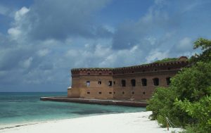
70 miles west of Key West sits a group of islands that when first discovered by the European explorers where reportedly home only to birds and turtles, hence the name Tortugas in honor of the Turtles. Attempts at making them useful were thwarted by the fact that there is no fresh water on the islands, thus the dry was added to the Tortugas.
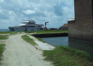
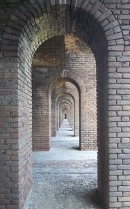
Nevertheless, the United States Government in the early 1800’s determined that the islands were vital to the security of the southern shores of the United States and began building Fort Jefferson. They built this house upon the sand and although it has had an interesting history, including a stint as the prison holding Abraham Lincoln’s assassin’s doctor, one Dr. William Mudd who was convicted of treason for setting John Wilkes Booth’s leg, the fort was never finished in accordance with its original plans. It was sinking too much and became obsolete while being built. Today, a small park service contingent and tourists on vacation, along with the occasional wayward Cuban refugee, are the primary people interested in Fort Jefferson and the Dry Tortugas. To get here, you can take the ferry, from Key West. The boat trip takes a little over two hours and day trippers can come to the island and stay until about 4:30 pm when the ferry returns to Key West. For the lucky few, however, overnight camping reservations are available. The reservations are limited and need to be made well in advance, however, the ferry ride can be arranged the day of your trip. If you don’t want to ride the boat for 2+ hours to get to the Dry Tortugas you can also take a seaplane from Key West for approximately the same price as the ferry. The seaplane, makes two trips per day and the guests get to stay about the same amount of time as the folks who ride the ferry. We spoke to the pilot who has been flying this route for the last several years and he says he has no intention of giving it up. Who can blame him, with living in the Florida Keys and making two short trips a day as his primary job? The plane is bigger than it looks, so if you want to be an overnight camper you can get your gear out here on the plane, however, we’d recommend the ferry. You can bring a cooler or two on the ferry which comes in handy since there are no provisions available on the island. Remember that you will be in the DRY Tortugas and that there is no water available on the island. Fill the coolers with ice and water and what ever other beverages and perishable items you will need for your stay and jump on the ferry. You can also get to the island if you are lucky enough to have your own private boat or a charter. While we were there a resident of the east coast of Florida showed up in his boat and anchored beside the fort. He single-handed the trip. I think I would have brought a friend. The limited campsites include a permanent grill and a picnic table, so you are essentially car camping from a boat, with no way to get to a store.
You are in a small grove of trees just to the south-east of the walls of the fort and there is not much else on the island. There were about 8 of us who came over on the boat and another 5 or 6 who came to the island on a private boat so after 4:30 in the afternoon the entire island was deserted except for the campers and a lone ranger who stayed in his quarters inside the fort. We were fortunate that we had great weather and were treated to an amazing spectacle in the sky at night as there was no ambient light to diminish the stars. We sat on the beach in the first picture above just south-east of the fort and were amazed at the stars you never see around civilization. The fort is an unfinished marvel.
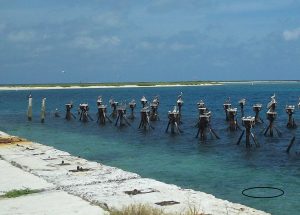
As noted above, during the decades it was being built the sheer weight of the millions of bricks began to make the fort sink, thus only the first and third levels of the fort were ever outfitted with cannons. Further, the invention of rifled bore cannons soon made the smooth bore cannons installed on the fort obsolete. The garrison stationed at the fort had to be truly miserable and the letters on display inside the small museum attest to the fact. Their uniforms were wool and they were required to wear them while stationed here even though the tropical heat and humidity would at times make them unbearable. A doctor and his family was stationed here, but ironically, the doctor fell ill and died from typhoid fever while Dr. Mudd was imprisoned here. Mudd then aided the sick and was credited for nursing many of them back to health. Eventually he was pardoned for his role in treating these patients after having been imprisoned for treating the wounded John Wilkes Booth. You will also be entertained by the permanent residents of the Dry Tortugas: the birds including the seagulls and the pelicans. The eastern part of the island is a bird sanctuary and you are not allowed to go there, but the pilings of the abandoned and long demolished coal resupply station provide hours of bird watching.
The dark area under the pilings is not grass but rather millions of bait fish in schools. The pelicans dive off the pilings to grab the minnows and the seagulls jump onto the head of the pelicans and try to steal the minnows out of their mouths. In the water, silver flashes cut through the bait fish (see the circled area) as mackerel feed on the minnows. The feeding goes on for hours until near sunset when the birds head off to roost. We were here in September, the shoulder season in Key West, when there were few tourists and lots of time. If camp overnight here, you may never have a more peaceful night. I’ll update this later on with a few more notes.
In an earlier post we promised to tell you how to do a Grand Teton backpacking vacation on a budget even though Jackson Hole is one of the highest per capita income places in the USA. Here’s how you do it.
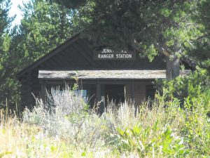
First, fly into Jackson, Wyoming airport. We used our credit card reward program miles to get there, so the cost was the redemption fee and giving up using the miles for another trip. Then, take a taxi to the Jenny Lake Ranger Station.
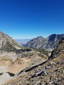
You have to go to the ranger station to get your backcountry permits, so while you are there get the permit and check into the backpackers campground. The campground for one night should run you about $8.00. The permit will cost you $35.00 regardless of how many nights you spend on the trail, so plan your trip to start with a walk up the Paintbrush from Jenny Lake. Your first night you’ll need a permit in the camping zones just east of Paintbrush Divide. This day hike should get you acclimated to the altitude because you’ll go over Paintbrush Divide at over 10000 feet into the North Fork of Cascade Canyon the next day, passing Lake Solitude.
Put the North Fork of Cascade Canyon on your permit for the second night and rest up to cross Hurricane Pass, also over 10,000 in elevation on the third day.
The third day will take you into the Alaska Basin where a short day will give you plenty of time to set up camp near Sunset Lake and enjoy the backcountry. No permit is needed to camp in the Alaska Basin as it is not in the Grand Teton National Park. Accordingly, you may have a number of campers around you instead of the solitude you get in the Park.
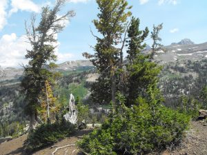
Leaving the Alaska Basin spend a day and a night on the Death Canyon Shelf or at Marion Lake, or if you don’t have time to relax on the trip, skip the night in the Basin and spend the third night on the Shelf.
Looking toward Mt. Meek from Death Canyon Shelf
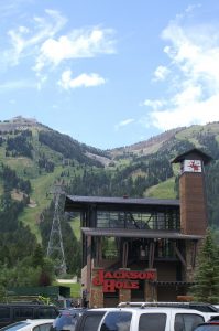
From the Shelf, you’ll go down past Marion Lake and pick up the trail up Rendezvous Mountain to the top of the TRAM, also above 10,000 feet. The Tram will take you down to Teton Village and there is no charge for the ride down. They only check tickets on the way up. If you ride up, it will cost you $35.00.
Tram
In the Village you can find low-cost accommodations at the Hostel. You can shower, shave, sleep and get ready to catch a shuttle to the airport, perhaps for as low as $3.
So, there’s your itinerary for the budget trip. Remember that the permits are limited and in short supply so you might want to try to secure them online before you go. This trek should be made in August or early September, so try to get your permits at recreation.gov between the preceding January 1 and March 15. You will still have to pick the permit up at the Jenny Lake Ranger Station when you get to Jackson Hole.
What will the trip cost you? Your airfare or credit card miles, one way taxi fare, $8.00 to camp at Jenny Lake, $35.00 for the backcountry permit, your night at the Hostel, the cost of the shuttle to the Airport and whatever food you eat. For a trip of a lifetime, that is a bargain. Of course, you’ll have to come back on another trip to explore the rest of Jackson Hole.
This is the first of four posts inspired by a phenomenal group of people who are advocates and conservators for our great outdoors and plan and facilitate great outdoor experiences for the rest of us. For this a personal debt of gratitude is owed to the Georgia Conservancy and their Mr. Bryan Schroder who Ramrods their adventure outings. We had gotten to know Bryan a little at one of the presentations he participated in at an REI store when we started kayaking and then again on a kayaking tour of the Okefenokee Swamp which we will highlight in another post on the blog in coming weeks, but this trip on the Altamaha was the turning point on resuming the Goneguru blog and sharing what we saw and encouraging you to meet up with us along a trail or around the bend of a river.
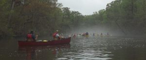
The Altamaha float to Darien is part of the Georgia Conservancy’s Heartland Rivers series of outdoor adventures. Go to their link above and you’ll get full data on this great series of canoe/kayak trips sponsored by the Conservancy and open to anyone. Better yet, go to the site, become a member, make a donation to preserve our waterways, and then take a trip with the Conservancy. We had been signed up for this trip for months and had regularly gotten updates from Brian about what to expect on the trip, accommodations for tent campers, kayak and canoe rentals, and basically any information any level paddler would need to prepare for the trip. However, as the date drew nearer the forecast on the Weather Channel grew more ominous. A huge storm was projected to cross the Altamaha on Saturday as we paddled down to Darien. Being on the wide Altamaha, the largest river in Georgia and one of the largest on the East Coast, in the middle of a violent thunderstorm with high winds wasn’t on any paddler’s bucket list. Brian reported that some paddlers were dropping out due to the weather and that the Saturday paddle had been changed to an out and back across the river into the tributaries with the longer downstream paddle moved to Sunday.
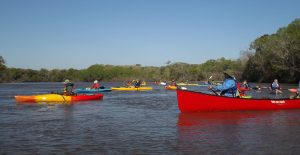
Most of us gathered at the Altamaha Regional Park just inside Glynn County, Georgia on Friday afternoon, with some choosing to join us early Saturday morning. It made little difference as the frontal system provided us with grey skies, cool temperatures and high winds throughout Friday and into Saturday morning. The Altamaha was flooded out of its banks and was roaring toward the ocean. As we enjoyed the low-country boil dinner under a shelter on Friday night, Brian and the other experienced paddlers, many from the magnificent Georgia Canoe Association, began to prepare us for the next morning’s transit across the river.
Looming just below the launch point at the campground is a massive abandoned railroad bridge and midstream island that threatened to act as a boat magnet for those who didn’t judge the current correctly. Brian and representatives from the GCA talked about the crossing and strainers and what our plan was to be. The next morning we had a safety briefing before we could enter the water and once on the water a GCA paddler demonstrated how to cross the river and went to the other side to mark our target channel for entry into the back water.
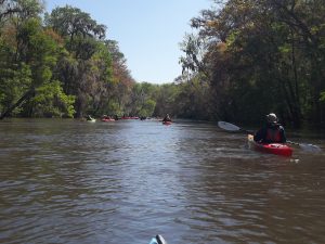
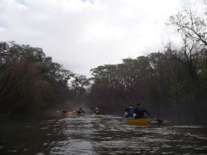
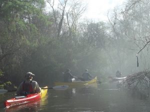
One we had safely crossed the river, we headed up into one of the creeks that feed into the Altamaha. As noted the river was flooded out of its banks and the storm that had passed the night before had given us a downward temperature shift and grey skies that made the daylight paddle a little surreal.
Looking upstream, we could see that there was a clear channel for the creek as we first entered it, but our hosts and guides had warned us that the seemingly tranquil waters could be dangerous once the channel narrowed and we began to get into areas where water didn’t usually flow.
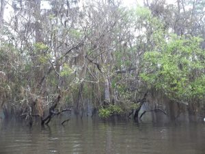
They explained that strainers are any obstruction that stops an object on top of the water from moving with the water as it flows past. Thus, when the water is out of the banks, overhanging tree limbs and shrubs reach down to and below surface of a water. A paddler who gets into one of these and grabs on will find that the water will take his boat right out from under him and gravity will put him into the water.
Altamaha out of the banks
I can assure you that we were well-instructed and informed of the dangers, nevertheless, two of our paddlers got to experience the effects of strainers first hand and were ingloriously helped back into their kayaks, wet but un-harmed.
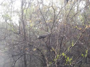
Of course the inhabitants of the wetlands adjacent the river have to move when the river floods and that includes the snakes. This picture isn’t very good, but you get the idea as to why there is another reason not to get caught in the strainers.
We were a cautious but not timid group so we dutifully filed through in single file where needed and kept our eyes on our fellow paddlers in case the need arose.
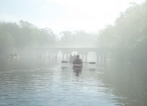
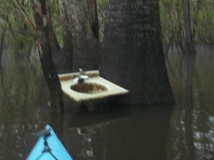
Sometimes the fog, flood and remnants of bygone days were simply eerie. The railroad had been built across the tributaries and presented a an eerie reminder of man’s abandoned encroachment into the river wilderness. Sometimes it wasn’t an intended abandonment at all but rather the river reclaiming its own property. We came across a fish camp with a canvas and wood hut and a porcelain sink. Of course, you’d be standing in thigh deep water to use it on the day we saw it.
After a few hours of paddling around in the creek and the flooded woods along the Altamaha it was time to head back across the big river to our camp. The GCA paddlers and experienced Georgia Conservancy paddlers, staff and volunteers took great care of the in-experienced paddlers and all the paddlers from novice to gnarly veteran finished up the day on the river with smiles and agreement that we had made a great day out of a day that threatened to be completely unusable.
That night under the big pavilion at the park, we were feed on barbecue with all the “fixin’s” or a vegetarian meal starring portabella mushrooms. Either way you couldn’t go wrong. The campers were as varied as their kayak experience with some in motor home RV’s and some in tents provided by the Georgia Conservancy, but they all agreed the trip was amazing. The weather had begun to clear and we were promised fair skies the next day so each and everyone was ready to get back on the river the next morning to head downstream the fifteen miles to Darien. If you would like to feel what its like to go on one of these amazing trips go to the Georgia Conservancy website and sign up.
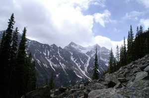
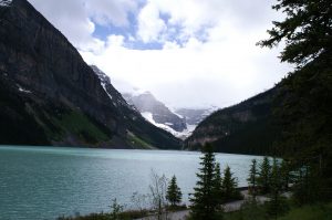
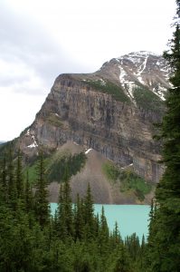
Lake Louise, Alberta, Canada (June 2012) If Banff is on your bucket list, then you need to fill your bucket up to the brim and drive a few miles northwest of Banff along the Trans Canada Highway to Lake Louise. The modern fascination with Banff and Lake Louise dates back to the late 1800’s when the Canadian Pacific Railroad made it possible for tourists and vacationers to get to the interior of the Canadian Rockies. Banff had and still has its hot springs while Lake Louise has this turquoise glacier feed water encircled by the towering Canadian Rockies.
Along the shore of Lake Louise
One grand chateau has replaced another over the years and today the Chateau offers all the modern conveniences and service one could ask for. But, the Chateau is not why people come here. The natural beauty of the region is surreal, even on a day such as we had when the clouds hung low, obscuring the mountain tops, and rain threatened as we stood by the lake. It was this natural beauty and a chance to walk among these giant mountains while soaking in the unending views that make you think every direction you look is more beautiful than the last that brought us here. We had a choice to make since we only had one day to hike at Lake Louise: would we hike to the Plain of Six Glaciers and visit the tea-house there, or hike up to Lake Agnes with its tea-house and head out to the Beehives? The trail-head for the two is the same, along the shore near the Chateau, however, we decided to do the Lake Agnes hike with a promise that someday we will return to hike other trails in this magical place.
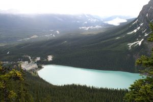
Looking down at the Chateau on Lake Louise
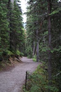
We had read several guidebooks before this trip and the Lake Agnes hike was described as strenuous to difficult, so we anticipated significant elevation gain and potentially rough terrain to cross. Lake Louise sits at about 5600 feet above sea level and the hike is a continuous up hill with no up and down or leveling out as you might have if you were walking a ridge-line so the altitude and the constant up hill do make it strenuous. But, probably because it gets so much use in the winter and summer and probably because it was used by rangers to go to fire stations on the beehives until the late 1970’s, the lower part of the trail was practically a boulevard to walk on.
The lower part of the trail
It is enticing, so we were not surprised when we were soon overtaken by two photographers dressed in street shoes and business casual attire. They smiled as us as they hurried by but three quarters of a mile up the trail, before the first switchback, we passed them panting on the side of the road. They had brought no water and did not ask for any but breathlessly asked how far to the top. We told them that the hike was about 3 miles long and that they were less than a third of the way up. They said they wanted to go to “the top” and take a picture of the lake and chateau. At this, point the lake was obscured by the trees, so when we told them that they were less than 1/3 of the way up they grimaced, looked at each other, and turned around. The image of the chateau above is probably what they wanted in the picture, but as you see a camera couldn’t really capture it. Less than a quarter mile after they turned around we came to the first switch back, which also afforded an opening for a view of the lake. We took pictures of the mountain across the lake and debated on whether we should hurry back down the trail to bring them to this spot.
Looking across Lake Louise
Moving up the trail was serenely peaceful. The trees gave way to the vista’s more often and we saw the lake below frequently. There was practically no one on the trail but us, as we had started the hike early in the morning. WARNING: If you start the hike at midday, you will be among a swarm of people for at least a part of the way up. We only encountered the large groups of tourists when we were near the bottom of the trail in the afternoon after we had made our hike.
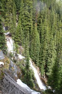
A couple of switchbacks brings you to Mirror lake, which is a small glacially fed lake that reflects one of the formations on the way up. The trail splits here with both branches leading up to the tea-house at Lake Agnes, however, the left leads to a junction with a trail to the Plain of Six Glaciers, so be careful if you go left. It is well marked but you have to keep your head up to see the markers. We went to the right and soon encountered the horse trail (unmistakable. Why don’t horse riders carry bags to clean up after their horses? Hikers would appreciate it!) The trail is not as pristine here but is not a scramble and soon leads to a paddock where the horses have to be tied and and a wooden stairwell beside the waterfall feeding out of Lake Agnes.
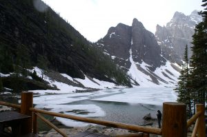
Of course, we had dressed appropriately for the hike, so I had a small bead of perspiration on my brow as we passed the waterfall and began up the stairwell. As we neared the top of the stair the wall of the tea-house came into view and the wind picked up. The temperature of the air dropped twenty degrees and pellets of sleet and snow started hitting me in the face and bouncing off my rain gear. Then we saw Lake Agnes, beautifully resting partially encrusted in ice and even more surrounded by the mountains.
Lake Agnes in Summer
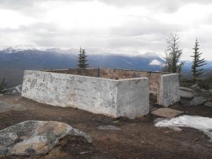
It was still early in the day, so we decided to press on to one of the Beehives. The Big Beehive is reached by following a path along the shoreline of Lake Agnes and making an assent around the lake. It is about a mile hiking distance and is said to be well worth the walk. We headed up the trail to the right, past the teahouse restrooms, and further up the mountain to the little bee-hive. Before too much longer the trail was covered over by snow and we saw where others had tried to make the passage before us. The problem was the tracks in the snow lead in different directions. We looked around and saw that the snow ended to the right of of us and the trail resumed, so we went to the right for a few hundred yards and cleared the snow. As I mentioned earlier, the Canadian Forest Rangers used a tower on the Little Beehive to watch over the forests and control potential fires up until 1978.
Tower base
The tower was removed but the base is still there along with a bench for sitting when you’ve expended your time and energy to reach this very peaceful place. There was no snow or rain and it was a beautiful summer day as we sat and enjoyed the view.
Resting near the top
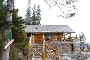
The Big Beehive actually has a gazebo like tower on it if you elect to go that route. We came back down the trail, crossed the snow patch again and headed down to the teahouse at Lake Agnes. We began encountering a few more people and when we entered the tea-house at around noon, there were only a couple of seats available. We gladly scooted into them, because as before, the wind was howling off the little lake with sleet and snow mixed in. The effect is similar to the winds in cities between tall buildings. Remember this when you go to the tea-house at Lake Agnes. They only take cash. No checks, no credit cards, no IOU’s. We had spent very little on our trip, but we had used credit cards and only carried a small amount of cash. Scraping together our change, we had enough for one bowl of soup. Fortunately, we had packed along a couple of sandwiches and plenty of water, so the soup and sandwich meal was fabulous!!
The Lake Agnes teahouse
The tea-house is built in a style popularized by the Swiss mountain guides who came to Alberta in the 1800’s to show the tourists how to climb the mountains. Its rustic, homey, and well worth your stop on the mountain.
We crossed a bridge across the stream from the lake that feeds the waterfall and headed down the alternate route mentioned earlier. The snow was a little trickier on this side and by now there were several groups of people who had made it as far as the tea-house and were heading down. The leader of one of the groups made an ignominious landing when he showed them how not to cross a snow pack across the trail. Fortunately, all that was bruised was his ego and his buttocks.
Going down may be more beautiful that coming up. The sun was trying to break through and the clouds were a little higher and the mountains at the end of the valley were spectacular.
On the trail below Lake Agnes
We came back down around Mirror Lake from the side opposite where we left, noting the trail to the Plain of Glaciers and made it back down to the Chateau on Lake Louise without incident other than running into the groups of people making their way up the trail in the early afternoon. Should you desire to go, note that there is a campground within a couple of miles of Lake Louise and if you are making it a day trip from Banff, there is a campground in Banff as well. If you decide to go, let us know, we’d love to go back and join you.
 from Key West. The boat trip takes a little over two hours and day trippers can come to the island and stay until about 4:30 pm when the ferry returns to Key West. For the lucky few, however, overnight camping reservations are available. The reservations are limited and need to be made well in advance, however, the ferry ride can be arranged the day of your trip. If you don’t want to ride the boat for 2+ hours to get to the Dry Tortugas you can also take a
 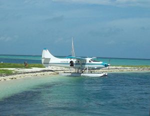 We spoke to the pilot who has been flying this route for the last several years and he says he has no intention of giving it up. Who can blame him, with living in the Florida Keys and making two short trips a day as his primary job? The plane is bigger than it looks, so if you want to be an overnight camper you can get your gear out here on the plane, however, we’d recommend the ferry. You can bring a cooler or two on the ferry which comes in handy since there are no provisions available on the island. Remember that you will be in the DRY Tortugas and that there is no water available on the island. Fill the coolers with ice and water and what ever other beverages and perishable items you will need for your stay and jump on the ferry. You can also get to the island if you are lucky enough to have your own private boat or a charter. While we were there a resident of the east coast of Florida showed up in his boat and anchored beside the fort. He single-handed the trip.
 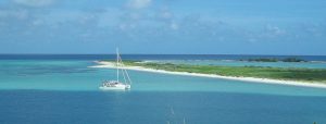 I think I would have brought a friend. The limited campsites include a permanent grill and a picnic table, so you are essentially car camping from a boat, with no way to get to a store.
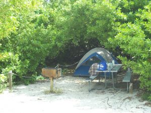


 (1024x768)")