Coeur d’Alene and Ironman Triathalon, too!

Coeur d’Alene, Idaho, USA (June 2012)   Near this tree on the banks of Lake Coeur d’Alene is a commemorative sign telling of the Native Americans who once gathered on the shores of the beautiful lake in northern Idaho.   After the Europeans came to America and made their way westward,

On the shores of Lake Coeur d’Alene

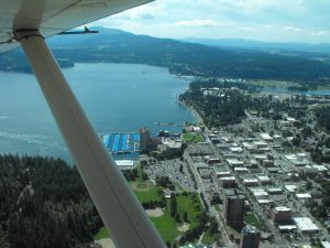
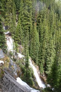
and the great railroads were built, Couer d’Alene took its spot among the beautiful hideaways of the west.  Easily accessible from the Spokane, Washington airport via I-90, Couer d’Alene presents a marked contrast with the sprawling and industrial Spokane.  The centerpiece remains the lake with its clear water surrounded by the green hills, but the town of Coeur d’Alene has done a lot to make the visitor welcome.
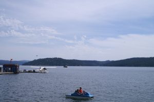
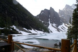
Lake Coeur d’Alene

The visitors have come and some with star quality names  have built homes in the area that we will only read about or fly over and look down on their pools and tennis courts and guest houses.

Along the lake the town proper is a mixture of shops and homes, where walking into the shops gave the impression that the shopkeeper was genuinely pleased to have you in the store, rather than the department store “I just work here” stare.  Walking to get about was clearly no problem and a pleasant hike around Tubbs Park will relieve the stress and provide you with some spectacular views of the lake.  We will return to Coeur d’Alene for its beauty and charm, and will come back to take our road bikes on the nearby Trail of Coeur d’Alenes  rails to trails project nearly spans the Idaho panhandle.  But, on this trip we were not brought to the town by any of these.

This trip we came to Coeur d’Alene for the Ironman Triathalon.  An Ironman Triathlon is not for everyone.  In fact it is only for the fittest of the fit.  Ironman competition began in Hawaii more than 25 years ago when several highly fit military men came up with their ultimate test based on swimming, cycling and running events in which they had participated.   The challenge they set for themselves was an open water swim covering 2.4 miles, a bicycle ride of 112 miles, and a marathon run, all in one day.  From a handful of participants on  that day the Ironman has grown into a world wide franchise, with thousands of participants testing themselves in Ironman sponsored events all over the world.  We have an Ironman finisher in our family, so we came to watch him participate, see Coeur d’Alene for the first time, and take a side trip to Banff.

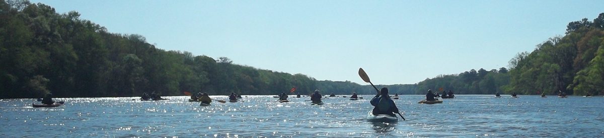
The first leg of the contest is the swim.  The men and women in their wetsuits lined up along the beach shown in the photo below to dash into the 57 degree F.  water where they would swim away from shore 0.6 miles, parallel the shore 0.2 miles, and back to shore where they would re-enter the water and do it again!

The start is awesome.  You might see 25 or 30 professionals start half an hour before the age classified amateur participants and it is inspiring to see the pro’s go at it, but the big rush is when the 2500 hit the water at the same time!

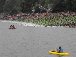
Coeur d’Alene swim start

Although it is a difficult spectator sport, as you can see thousands of supporters for the athletes were en masse near the beach and along the seawall yelling and urging their favorite participant on.  The water sorts the athletes out by their ability, with swimmers straining stroke after stroke to finish the 2.4 miles before the two and one half hour time limit expires.  Then, they run across the sand to the the transition area where they are helped out of their wetsuits, into warming rooms if they need them, and onto their bicycles.  Some are unable to continue beyond the swim.

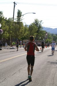
The bike ride is 112 miles.  For this part of the race,  a lane of US 95 heading south from Coeur d’Alene and major streets in town were closed to trafffic.  It is along the streets that you will get the best views of the cyclists.

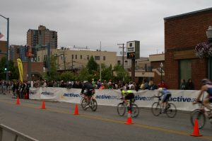
Ironman Tri-athalon cyclists

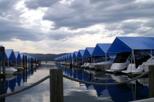
Although, the bike ride is also two laps, the laps go so far out of town that each athlete is out of sight for hours, so for a spectator there is plenty of time to grab a bite to eat, see the sights, and get ready for the next time your athlete speeds by.  Some say the smart ones take a nap.  We chose to walk around the world’s largest floating boardwalk adjacent the Coeur d’Alene Resort.  The boardwalk is 3300 feet long and surrounds the marina.  If you look at the boats tied up in the Marina, you’ll understand that quite a bit of money is spent on the enjoyment of Lake Coeur d’Alene.

Looking at the Marina from the Boardwalk

We also took in some of the shops and a couple of miles of trails in Tubbs park before it was time for the marathon part of the competition.

The marathon is grueling.  Even the fastest finisher has to run part of his marathon in the heat of the day.  26 + miles in two laps through the city streets of Coeur d’Alene.  Although we cheered the athletes on, there is no team in this sport. Each athlete is on his own, testing his or her own willpower to put one foot in front of another.

Punishing afternoon sun

Now they are faced with the final deadline: Be across the finish line by midnight or you are not deemed to have finished the race at all.  For some, what started filled with adrenalin at 7:30 in the morning will end in anguish after midnight.  But for most, they will hear the crowd cheer and give high-fives as they near the finish line.
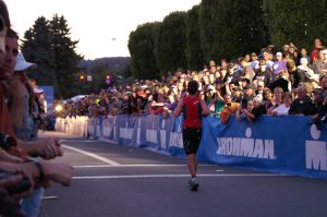
The Finish

The finishers are checked by medical personnel, wrapped in thermal reflectors to keep their bodies warm as walk around with family and friends or head to their bed.  Many come back to near the finish line or sit where they can hear the music playing and hear the announcer give voice to the name of each finisher.  Deep into the night the music plays and the names are called out. Then, at midnight, the music stops, no more names are called, and the crowd leaves.   What seemed forever to train for and watch is suddenly over, but the Ironman finisher has a memory and medal that should last a lifetime.

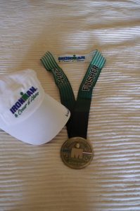
Ironman Finisher’s medal

Lake Louise to Lake Agnes: A vacation hike worth the walk near Banff

Lake Louise, Alberta, Canada (June 2012)  If Banff is on your bucket list, then you need to fill your bucket up to the brim and drive a few miles northwest of Banff along the Trans Canada Highway to Lake Louise.    The modern fascination with Banff and Lake Louise dates back to the late 1800’s when the Canadian Pacific Railroad made it possible for tourists and vacationers to get to the interior of the Canadian Rockies.  Banff had and still has its hot springs while Lake Louise has this turquoise glacier feed water encircled by the towering Canadian Rockies.

Along the shore of Lake Louise

One grand chateau has replaced another over the years and today the Chateau offers all the modern conveniences and service one could ask for.  But,  the Chateau is not why people come here.  The natural beauty of the region is surreal, even on a day such as we had when the clouds hung low, obscuring the mountain tops,  and rain threatened as we stood by the lake.   It was this natural beauty and a chance to walk among these giant mountains while soaking in the unending views that make you think every direction you look is more beautiful than the last that brought us here.   We had a choice to make since we only had one day to hike at Lake Louise: would we hike to the Plain of Six Glaciers and visit the tea-house there, or hike up to Lake Agnes with its tea-house and head out to the Beehives?  The trail-head for the two is the same, along the shore near the Chateau, however,  we decided to do the Lake Agnes hike with a promise that someday we will return to hike other trails in this magical place.

Looking down at the Chateau on Lake Louise

We had read several guidebooks before this trip and the Lake Agnes hike was described as strenuous to difficult, so we anticipated significant elevation gain and potentially rough terrain to cross.  Lake Louise sits at about 5600 feet above sea level and the hike is a continuous up hill with no up and down or leveling out as you might have if you were walking a ridge-line so the altitude and the constant up hill do make it strenuous.   But, probably because it gets so much use in the winter and summer and probably because it was used by rangers to go to fire stations on the beehives until the late 1970’s, the lower part of the trail was practically a boulevard to walk on.

The lower part of the trail

It is enticing, so we were not surprised when we were soon overtaken by two photographers dressed in street shoes and business casual attire.  They smiled as us as they hurried by but three quarters of a mile up the trail, before the first switchback, we passed them panting on the side of the road.  They had brought no water and did not ask for any but breathlessly asked how far to the top.  We told them that the hike was about 3 miles long and that they were less than a third of the way up.  They said they wanted to go to “the top” and take a picture of the lake and chateau.  At this, point the lake was obscured by the trees, so when we told them that they were less than 1/3 of the way up they grimaced, looked at each other, and turned around.  The image  of the chateau above is probably what they wanted in the picture, but as you see a camera couldn’t really capture it.   Less than a quarter mile after they turned around we came to the first switch back, which also afforded an opening for a view of the lake.  We took pictures of the mountain across the lake and debated on whether we should hurry back down the trail to bring them to this spot.

Looking across Lake Louise

Moving up the trail was serenely peaceful.  The trees gave way to the vista’s more often and we saw the lake below frequently.  There was practically no one on the trail but us, as we had started the hike early in the morning. WARNING: If you start the hike at midday, you will be among a swarm of people for at least a part of the way up.  We only encountered the large groups of tourists when we were near the bottom of the trail in the afternoon after we had made our hike.

A couple of switchbacks brings you to Mirror lake, which is a small glacially fed lake that reflects one of the formations on the way up.  The trail splits here with both branches leading up to the tea-house at Lake Agnes, however, the left leads to a junction with a trail to the Plain of Six Glaciers, so be careful if you go left.  It is well marked but you have to keep your head up to see the markers.  We went to the right and soon encountered the horse trail (unmistakable. Why don’t horse riders carry bags to clean up after their horses?  Hikers would appreciate it!)  The trail is not as pristine here but is not a scramble and soon leads to a  paddock where the horses have to be tied and and a wooden stairwell beside the waterfall feeding out of Lake Agnes.

Of course, we had dressed appropriately for the hike, so I had a small bead of perspiration on my brow as we  passed the waterfall and began up the stairwell.  As we neared the top of the stair the wall of the tea-house came into view and the wind picked up. The temperature of the air dropped twenty degrees and pellets of sleet and snow started hitting me in the face and bouncing off my rain gear.  Then we saw Lake Agnes, beautifully resting partially encrusted in ice and even more surrounded by the mountains.


Lake Agnes in Summer

It was still early in the day, so we decided to press on to one of the Beehives.  The Big Beehive is reached by following a path along the shoreline of Lake Agnes and making an assent around the lake.  It is about a mile hiking distance and is said to be well worth the walk.  We headed up the trail to the right, past the teahouse restrooms, and further up the mountain to the little bee-hive.  Before too much longer the trail was covered over by snow and we saw where others had tried to make the passage before us. The problem was the tracks in the snow lead in different directions.   We looked around and saw that the snow ended to the right of of us and the trail resumed, so we went to the right for a few hundred yards and cleared the snow.   As I mentioned earlier, the Canadian Forest Rangers used a tower on the Little Beehive to watch over the forests and control potential fires up until 1978.

Tower base

The tower was removed but the base is still there along with a bench for sitting when you’ve expended your time and energy to reach this very peaceful place.  There was no snow or rain and it was a beautiful summer day as we sat and enjoyed the view.

Resting near the top

The Big Beehive actually has a gazebo like tower on it if you elect to go that route.  We came back down the trail, crossed the snow patch again and headed down to the teahouse at Lake Agnes.  We began encountering a few more people and when we entered the tea-house at around noon, there were only a couple of seats available.  We gladly scooted into them, because as before, the wind was howling off the little lake with sleet and snow mixed in.  The effect is similar to the winds in cities between tall buildings.   Remember this when you go to the tea-house at Lake Agnes.  They only take cash.  No checks, no credit cards, no IOU’s.  We had spent very little on our trip, but we had used credit cards and only carried a small amount of cash.   Scraping together our change, we had enough for one bowl of soup.  Fortunately, we had packed along a couple of sandwiches and plenty of water, so the soup and sandwich meal was fabulous!!

The Lake Agnes teahouse

The  tea-house is built in a style popularized by the Swiss mountain guides who came to Alberta in the 1800’s to show the tourists how to climb the mountains. Its rustic, homey, and well worth your stop on the mountain.

We crossed a bridge across the stream from the lake that feeds the waterfall and headed down the alternate route mentioned earlier.  The snow was a little trickier on this side and by now there were several groups of people who had made it as far as the tea-house and were heading down.   The leader of one of the groups made an ignominious landing when he showed them how not to cross a snow pack across the trail.  Fortunately, all that was bruised was his ego and his buttocks.

Going down may be more beautiful that coming up.  The sun was trying to break through and the clouds were a little higher and the mountains at the end of the valley were spectacular.

On the trail below Lake Agnes

We came back down around Mirror Lake from the side opposite where we left, noting the trail to the Plain of Glaciers and made it back down to the Chateau on Lake Louise without incident other than running into the groups of people making their way up the trail in the early afternoon.  Should you desire to go, note that there is a campground within a couple of miles of Lake Louise and if you are making it a day trip from Banff, there is a campground in Banff as well.   If you decide to go, let us know, we’d love to go back and join you.


Ponies, bikes, trails, and the Virginia Creeper

Along the Virginia – North Carolina border, near the little town of Damascus, a section of the Appalachian Trail runs out of town over the mountains and through Grayson Highlands State Park.  Damascus itself is noteworthy as a resupply station for the Appalachian Trail through hikers.  Grayson Highland is an amazing state park with great camping facilities set in a remote setting not too far from I-81. In between the two of them, you’ll find the Virgina Creeper, or maybe you’ll go to do the Creeper and explore Damascus or Grayson Highlands.  Either way, give yourself a couple of days in the area to soak it all in.

You can start your hike on the Appalachian Trail approach trail inside Grayson Highland and head up to Mt. Rogers if you are a peak bagger.  Mt.  Rogers is the highest peak in Virginia and is only few miles away from the parking lot in Grayson Highlands.  Expect to see the wild ponies along the way.

The wild ponies in Grayson Highlands State Park.

From the photo above, you might not guess it, but we were on the trail in August.  The temperature was in the mid 60’s and there was a dense fog most of the day.  A hurricane had moved up the east coast and although it wasn’t directly affecting our weather, we felt that it was.  It also has something to do with the park being at about 4,000 feet above sea level.  The horses are quite used to people and came right up to us as if to beg for a snack or to be  petted.  We gave them no snack but we did rub their backs and scratched their ears a bit.  The hike was easy to moderate, however, since we were in the fog and uncertain about sundown we did not make it all the way to Mt. Rogers.  Be sure to carry an accurate map and compass as the area between the parking lot is criss crossed with horse trails for riders and hiking trails with somewhat confusing markings.  We did alright but we went out of our way on the return trip when we consulted with another group as to which way they had come.  I can’t attest to the vistas because of our cloud cover, however, the area was largely a bald or meadow area, thus on a clear day you would have undoubtedly had a great view.

The campground at GHSP is a great car camper park with a variety of sites that can be reserved in advance to suit your camping needs including running water and electricity, or, you may elect a site that does not have electricity.  It is a family friendly camping area, where one little boy ran up to us excitedly as we drove in, only to be disappointed when we told him there were no children with us.  It is east of Damascus by about 30 miles and will take you the better part of an hour to get there. There is a camp store and bathhouses as shown in the link.  You may want to consider checking out the Mount Rogers National Recreation area for some camping in a little less crowded area.  The Beartree Recreation Area campground has primitive sites without hookups.  Hurricane Campground has sites with tent pads and fire rings.

Along side the road between Damascus and the park, and in fact from Abington, Virginia adjacent Interstate 81 into Damascus and beyond for about 17 miles is the famous Virginia Creeper Trail.  Total length of the trail is about 34 miles.  We had decided that we would ride the Creeper’s eastern end, downhill from White Top to Damascus on our way home from camping and hiking, but we hadn’t brought bicycles with us.  So we stopped along side the road at a rental shop and picked out a couple of mountain bikes to make the ride.  An ordinary hybrid would do fine as the trail is well packed cinder that follows the old railroad track at a grade of less than about 7% all the way into Damascus.  We budgeted two hours for the 17 miles since we consider our selves experienced cyclists on our road bikes and hybrids.  What we didn’t count on was the peaceful beautiful scenery and the glimpse of the past you’ll encounter on this mellow ride.

Virginia Creeper Trestle
Beneath the Trestle

Because the trail was built for use by steam powered trains trestles were used to eliminate the ups and downs of the valleys and hollows.  Stepping to the side of the trail, you will be pleased to see how well maintained the trestles are and will be amazed at the work and ingenuity that went into building the trail decades ago.

trestle top

Don’t limit yourself to two hours on this trial.  Take a couple days and take your time.  You’ll find plenty to see, an ice cream store or two, sandwich shops and other “creature comforts” along the way.  Best of all, find an older local to talk to.  The lady that rented us the bikes we used had lived beside the Creeper all her life.  She told us things to look for, like the place she went skinning dipping 65 years ago, that you would never look for on your own.  Enjoy.

,


Bike Ride Across Georgia: Spring Tune-Up / Summer Fun

For 33 years adventurous cycling spirits have literally rolled across the state of Georgia.  I wasn’t there when it started and, in fact, have only participated in the June Bike Ride Across Georgia (BRAG) ride four times, but, once you’ve done it you will either always want to do it again or never want to do it again. There really is no in between.  The years that I did it, the majority of the of the riders were veterans of prior rides, so for my money, the do it again crowd far outweighs the others.  Every year in June, I wish I was on the road again.  To get you “ready” for the 7 day ride across the state, BRAG sponsors a spring tune-up around Madison, Georgia. I’ve done these a few times.  The pictures on this blog are primarily from the Spring 2012 tune up with some older pictures thrown in.

First some facts.  2012 Bike Ride Across Georgia starts June 3, near Chattanooga, Tennessee with stops at Dalton, Jasper and Roswell, which is just north of Atlanta for a day of rest before turning north again to Winder, Mt. Airy, and ending in Tiger on June 10.  For real details, go to the official BRAG website .  Essentially, this years seven day ride covers about 320 miles with a rest day on the 4th day.  Some of the cyclists will use this “rest” day to complete a century ride (100 miles).   The official ride days range from 40 to 72 miles in distance with rest stops every 10 to 15 miles on average.  If you ever want to learn how to run a ride, then you should ride BRAG and watch how the rest stops and SAG wagons work.  The volunteers manning the rest stops can’t be beat and the people in the support vehicles never fail to help you out.  Sometimes, in June, Georgia is a little hot and these folks make sure any cyclist who isn’t on their A game gets to the next stop.  Further, you need to watch the care BRAG gives to the Special Olympians who ride with them every year.  You will see some very special people.

The Spring Tune Up started on Friday with rides from Madison’s Heritage Park with the Brer Rabbit Ride.  Saturday brought the Oreo Cow ride which gave the cyclists another opportunity for a century ride or the optional 57 mile Blue Willow ride which generally meanders westerly over to Social Circle, home of the Blue Willow Inn.  Sunday brought the Rock Eagle Ramble which would take a rider past the Georgia 4-H camp and back to Madison past the Stefan Thomas Museum.  Here’s how I saw it from the Bike.

A Madison home from long ago

Madison is one of those old southern towns with many old homes that have been taken care of and now provide a glimpse into an earlier time.  The house above, stands beside the Saturday and Sunday routes and is striking, but you might have liked another just as well.  Sometime during the year, there will be a tour of homes and this one may be on it.

Riding by the rails

Leaving town you’ll cross the railroad tracks that once upon a time tied the small towns of the south together and carried merchandise and people across the states.  Today, they speed past the whistle stops loaded with freight and cars and things bound for distant places while the old depots have been torn down or turned into different uses.  Out of town, you’ll find what many of us ride for: Vista’s like these

Making Hay

where you have time to look and linger on the bike while watching the cyclist ahead of you and the car behind.  The bicycle riders who do these rides are ordinary people who do extraordinary things.  The people who organize these rides are extraordinary people who create an extraordinary event.


Riding with your friends

On Sunday, near the end of the last day’s ride, you will come across something else quite extraordinary.

A museum in a cow pasture

The Steffen Thomas Musem of Art sits aside Bethany road adjacent farm fields and cow pastures and  has served as a rest stop for the Spring Tune up for a number of years.  We had stopped outside several times, but this year, the door opened and we went in.  It is an exceptional museum and serves as a cultural anchor not just for Madison but for a much wider area and audience. More importantly the Museum is dedicated to educational programs to reach many of the places our bicycles, cars and trains roll past.  We’ll feature the museum in another article, but if you are near Madison for whatever reason, don’t wait for us to write about it.  Go see for yourself.  Meanwhile, bike, camp, live and learn.


Something new in the Smoky Mountain NP for the Through Hikers near the Appalachian Trail

Our little group just finished another hike to Mount LeConte near Gatlinburg, Tennessee, USA.  I’ll post all the details later, but I wanted to share a part of the trip with you in a condensed version.  We were at the top of Mt. LeConte for two nights spending the entire day there on April 27.  As usual the weather was changeable. We had hiked up in a thunderstorm on the 26th and had intermittent clouds and sunshine most of the 27th.

The dining hall at LeConte Lodge

As  you can see above the day started off with clouds. It was somewhat humid, but the temperature by afternoon was in the mid 50’s Fahrenheit.  Our intention was to spend the day hiking around the top of Mount LeConte and taking it easy.  We had come up Alum trail again which is a fairly strenuous trek, particularly in the rain of a thunderstorm.  We wanted to go over the top of the mountain to Myrtle Point, which affords the best views of sunrise on Mount LeConte, to spend an hour or two in the afternoon resting on the rocky ledge looking out over the Great Smoky Mountain National Park. As we pushed along we soon saw an unmistakable image of why these mountains are called the Smokies.

The mountain billowing smoke

Looking at the above picture, the view is along a ridge that runs south from Mount LeConte.  The Boulevard trail follows this ridge from LeConte to the Appalachian Trail.  The wind is from the west, or moving from right to left in the picture. As the wind rises up from  rises up from the valley to the crest of the ridge there are no clouds to the west, but as soon as the wind crosses the ridge, clouds boil up from the east side like  smoke from a volcano, creating a vision of smoke rising out of the ground.  After a couple of hours it diminished, but it was an amazing sight while it lasted.

A view from Myrtle Point.

On Myrtle Point, even with the Smokies haze, the view is what you go to the mountains for.  Although, you might see something similar from a car, there is nothing like getting to the top of a 6000 foot mountain on your own feet and taking your shoes off while resting in the sun and the clouds.  Yes, sometimes you are in the clouds.  Myrtle Point juts out into space and is a granite point surrounded by low growing Myrtle shrubs.  It is accessible only by walking at least six and a half miles up and over Mount LeConte or by hiking over seven miles from Newfound Gap along the Appalachian and Boulevard trails.  Thus, the view above  is not a sight everyone will see with their own eyes. You should try though, because it is incredibly peaceful and restful, to sit there and look out at the mountains and the ever-changing sky.

Near the crest of Mount LeConte, along the Boulevard trail, there is an Appalachian Trail through hiker shelter that gives the through hikers a respite if they decide to take Boulevard to LeConte and then venture down into Gatlinburg.  Since our last visit to LeConte about 6 months ago, the National  Park Service installed a new composting toilet for the use of the through hikers.  It seems to work well, but like every thing else I’ve been talking about.  It’s up hill to get there.  In fact, at the bottom of the Alum Cave trail the National Park Service erected this sign which has warnings to hikers to take precautions

National Park Service Trail Map and Warning

because of the footing.  The sign states, in part: “This trail is steep and rocky.  Wear sturdy boots with adequate ankle support.”  Further, if you look closely, you will see that the sign also indicates that the summit is over five miles away, at over 6,500 feet and takes four of five hours of hiking to reach.

An easy part of the Alum Cave Trail

The part of the trail shown above is in the lower half of the trail. As I stated earlier, the new composting toilet at the through hikers shelter is near the summit of Mount LeConte and there is no way to get there, except on the trails.  So, take a look at what the National Park Service installed for the through hikers to use.

ADA toilet at 6500 ft elevation along a rocky trail at least six miles from the nearest road.

They have their very own Americans with Disabilities Act approved toilet.  I have carried a back pack up or down every trail leading to this toilet on all sides of Mount LeConte.  I guarantee you that any person who required such a toilet as part of his/her normal life would not be able to roll their wheel chair to this toilet, even if you carried them to a spot within a quarter of a mile from the toilet. At Goneguru, we want everyone to have a quality life and to enjoy travel and the great outdoors.  We support research for such disabling diseases as Multiple Sclerosis, but some things just don’t make sense.   If you can explain to me the logic in why this toilet was configured to be ADA approved, please do so.

Len Foote Hike Inn-An Inn in the Woods for Everyone

This article provides the answer for the family or couple or group of friends who want to spend some time in the great outdoors, but need different levels of comfort in the adventure.  Some need a bed, some a toilet, some a shower, some a hot meal, some could do without any of these but need the companionship of someone who can’t.  You can share the adventure without missing any of what you need.  If you are willing to go for a walk in the woods with friends, or want to do it alone and get to a place where you won’t be alone, we have the answer for you.  That is, unless you need a cell phone.  You won’t find or need any of those here.

I’m one of those people who say I  would love to hike the Appalachian Trail, but in truth know that I never will be willing to sleep outside for four or five months and carry a pack sixteen hundred miles along the eastern half of the United States.  Nevertheless, I can enjoy the outdoors along the trail, hike parts of it, and still benefit greatly from the fact that the Trail exists.  If you don’t know anything about the Appalachian Trail, anything about camping, or backpacking or even have any desire to learn these things, you can enjoy an easy to moderate hike up a well maintained trail near the start of the Appalachian Trail, spend the night in a green certified lodge in the mountains, and count yourself among those lucky enough to see nature at its best.

Find your way to Amicalola Falls State Park in the  Chattahoochee National Forest in north Georgia, a few miles south of the official southern end of the Appalachian Trail (AT) on Springer Mountain.  The trail to the Len Foote Hike Inn starts at the upper end of the upper most parking lot in the Amicalola Falls State Park and takes you  gently up into the mountains.  The approach trail to the AT starts at the same place but branches off.  The trail to the Len Foote Hike Inn takes you five miles into the mountains to the Hike Inn and then rejoins the AT approach trail  a mile above the lodge, thereby giving you an option to hike up one trail to the Len Foote Hike Inn and come back down on another trail.

Arriving at the Hike Inn, you’ll notice that the structure is on stilts and although it is quite large, it has a very small footprint and has a very slight impact on the natural space in which it is situated.  The Inn will provide you with all you need for a peaceful retreat, but, you won’t find a television, radio, or cellphone on the premises.  You might find that you rather like it that way in this place in the woods.

 This eco-friendly or green philosophy permeates the Inn.   The roof top supports twenty-four photovoltaic solar panels that provide a percentage of the electricity used there.  Composting toilets in the bathhouse provide an odor free way to save hundreds of thousands of gallons of water.  Rain barrels collect water used to water the garden and vermiculture beds use earthworms to turn the Inn’s kitchen scraps and office paper into fertilizer for the gardens.  The Inn has a gold level LEED certification and a Backyard Wildlife Habitat certification from the National Wildlife Federation.   If you arrive at the Inn before 5 PM, you can take the tour of the facilities and perhaps learn a few tricks you might want to apply at home.

Although you could go up and down in a day, you’ll want to stay.  The sleeping area provides bunk beds in each room.  You’ll find that  hot showers, sinks, mirrors and towels are provided.  Perhaps you will wake up and decide to spend an a hour in the sun room, which really should be called a rain room, because who would want to be inside in this locale when the sun was shining outside.  However, if you do stay in the sunroom you will find it open and comfortable with a ceiling high enough to make you feel like you are outdoors.  Or perhaps is will be some quiet time alone looking into the distance on the wrap around porch.

Better, yet make a couple of new friends and find the chairs overlooking the Georgia mountains and tell each other of your tales.  You’ll use washable cups and glasses that you put your name on with a biodegradable tape, so sit in one of the great chairs and refill your cup for a few minutes of peace.

No matter what you do while you are there you will find that the time passes as quickly as the sun through the eye of the needle atop the mountain.  Taking a cue from the ancients who used sundials for tracking time, this sun’s eye has three great boulders that line up with the sun’s location relative to the eye at the equinoxes and the longest and shortest day of the year.

The eye of the Sun

Since the Inn is open year round, you may want to plan your hike to coincide with one of these.  The sight you see may not be a serpent crawling down a pyramid as you would see at Chitzen Itza, but it is still symbolic of the balance between the sun, the earth, nature and man, so its a great icon for the Len Foote Inn.  As we said in the beginning, this is a great place for each of you, regardless of what you think you might need when you spend a night in the woods.


Crosses and Castles and Close Encounters – Ireland

Not everyone in the world has an Irish Heritage, but on  St. Patrick’s Day many a lad and lassie believe that somewhere in their ancestral past is the vestige of Éirinn go Brách .  My wife is legitimatley part Irish and  I can trace my ancestry back to Dublin, but my Dublin is a city in America, not Ireland, however, even in this American town,  the celebration of all things Irish is roundly upheld.  When the opportunity arose for us to go to Ireland there was certainly no reason not to go.  This little article shows a few  pictures of a personal Ireland on a trip taken around St. Patrick’s Day and shows a few spots in Ireland from a personal point of view.

Celtic cross

The cross above stands in a graveyard in Killarney National Park.  I don’t know the identity of the interred, but I am grateful for the beauty of the resting place.  To the best of my recollection, this image was taken at Muckross.  Nevertheless, it represents crosses we saw all across Ireland on our trip there.

Like many others we started in Galway and ended in Dublin, with too little seen in between.  We were there in early spring, so the images you see should reflect the Irish landscape around St. Patrick’s Day.  But, don’t take our word for it.  Go see for yourself.   Even at the early date of our trip, you could none the less tell the beauty of this green island and its well earned lore.  I was surprised by the hilliness and the beauty of the lakes resting in the valleys.

Irish lakes and hills

The Connamera region of Ireland is full of mountain, lake and bog land, with a rugged beauty that may not fit with the bright image of Ireland that you may have. However, it can bring to mind the potato famine of the mid 1800’s that sent so many Irish to foreign shores that each of us now feel an Irish kinship.  In the midst of this ruggedly beautiful land, you will find man made places that are unimaginably beautiful. One of these is Kylemore Castle  which is currently inhabited by the Benedictine Order of nuns also known as The Irish Dames of Ypres. 

Kylemore Castle

This is a “modern” castle, built in the 1860’s, and purchased by the Benedictine Oder in 1920.  Like much of Ireland, its history can be considered tragic or uplifting and I will leave it to you to research and decide which you think it is.  Here is a link to a website that will be helpful.    http://www.kylemoreabbeytourism.ie/benedictine-community .

Far to the south of Kylemore Castle, you will find a castle that is far more famous and which is on the ‘to do’ list of almost any tourist to Ireland.  I am referring to the famous Blarney Castle. According to the legend,  if you kiss the Blarney Stone. you will be gifted with the ability to tell a tale with your listener’s being unable to determine whether you are telling the truth or lying.  Blarney Castle sits on a beautiful setting but, because it sits right beside a rather mundane road, upon arriving, you may wonder if you’ve arrived at all.  None the less, a few feet along the path you realize that you are in a special place, even if you aren’t sure why.

Blarney Castle

The castle does not look like a “Disney” castle, but was clearly a functional fortress, capable of defending her master’s interests.  To kiss the Blarney Stone, one must ascend to the top level of Blarney Castle, find the opening in the parapet that is designated as the “stone”, lie down on your back and extend your face into nothingness until your lips press against the wall.

Kissing the Blarney Stone

It take some concentration as well as trust in the one holding your legs.   As you can see the person kissing the stone hangs his/her head between heaven and earth.   Note also the modern day grip bars installed to allow even the most reticent tourist to kiss the stone.  I, for one, think it should be done the old fashioned way with neither grips nor assistance.

Getting around in western Ireland gives you a great appreciation for the skill and courage of the Irish drivers and lorry-men who navigate these roads.  The roads can be narrow and closely bordered with the ubiquitous Irish stone fences setting out the fields of one landowner from another.  In this photograph,

Close Encounter

the two drivers of the oncoming buses, squeezed their buses through a space that left no more than 4 inches separation. No dents, no bumps no bruises.  These narrow roads will take you past the traditional Irish fields that you have to say you’ve seen.  No trip to this emerald Isle can be complete with out looking out over the patchwork Irish countryside divided by the stone fences,

Irish Countryside

each set with no mortar and expected to stand forever.   Some of these fences are hundreds of years old and hearken back to an earlier time in this place where  peat was burned for heat an thatched roofs held sway.   In some places, the old ways live on.

Peat Pile

Beyond the green fields you come to the land of peat. As you can see, the peat is cut into short logs for burning and it is indeed still burned.   Perhaps you will find a village in which some of the houses still have thatched roofs.  Blarney Castle, peat bogs and thatched roofs  alongside green fields and stone walls were what I expected when I came to Ireland and the land did not disappoint me.

Thatch covered houses in a row

Although the houses above were not the little cottages in the field I had envisioned, they gave me the imagery of the houses I had wanted to see.

From the western shore of Ireland, the Atlantic stretches to America.   On that shore you’ll find the Dingle Peninsula, where some of the most scenic stone walls fields and seascapes will be found and to the north you’ll find the Cliff’s of Mohler jutting between sea and sky and providing sanctuary to thousands of birds.  Although no one can own the scenery, standing there on the cliffs and looking along the shoreline, you feel as though you belong to it, even if it can’t belong to you.  Even when you try to capture it in a photograph, you look back and realize that you couldn’t really show what you see.

The cliffs of Mohler

Once you’ve  seen these cliffs and the images of Ireland will  reappear in your memory and even in your dreams, some times in the strangest ways.

From the Celtic Cross to the cliffs of Mohler and back to Dublin, the emerald isle captures your imagination and lets you blend history and fantasy into one, taking part of the tales of Ireland you may have heard and fixing them in places you finally see with your on eyes.    Even when you visit Dublin and all of its bustle, there may be time for you to visit the Papal Cross that was erected near the edge of the Fifteen Acres in Phoenix Park and contemplate all that you have seen.

The Papal Cross in Phoenix Park, Dublin

Tampa: Beach Camping Oasis 10 minutes from Town

We’ve previously posted articles about backpacking on Cumberland Island, but this post is for those of you who are looking for a great beach campground for car campers.  You’ll find it at Fort  De Soto Park near Tampa, Florida.  According to one of the Rangers we spoke to at the campground, twenty-five years ago Tampa Bay was a polluted mess and the area around Mullet Key on which Fort De Soto  is located had brackish backwater that couldn’t circulate and a dying grassy area  in the bay that soured and smelled, particularly in the summer months.  Cooperation between local, state, and federal agencies and the local conservation groups cleaned up the bay, cut new channels for water flow through and around Mullet Key and today the area is a haven for campers.

The island is reachable by a bridge from the Bayway or by water, but what will strike you is the fact that it has remained largely undeveloped.

Birds on the public pier looking at the beach

If you look at the background in the picture above you will see the stretch of beach running from the Bay Pier up to North Beach.  Note that there is not a single highrise nor even a house on the beach.  If you go south from this point, you’ll enter the Bay pass the Bay pier and reach the tip of the island passing only the Park Headquarters building, restrooms and park concessions.  That is to say, other than the buildings necessary to provide services to the visitors, there are no other buildings on this island.  As you skid through Tampa on I-275, you will not believe you are going to a place as tranquil as this.

Fort De Soto Park Campground sits directly adjacent Anderson Boulevard, so it cannot be missed in terms of passing it by, but it might be missed in terms of getting a reservation.  Reservations are taken 6 months in advance, unless you are a Pinellas County resident in which case you get an extra month.    The campground holds back 10% of its 250 campsites for walk-ins.  On the weekend, a walk-in can reserve a campsite for two nights.   We asked the Ranger at check in about this and when one should arrive to be certain of a campsite.  He said that the Ranger office opens at 7 a.m. , but that walk-ins would often arrive as early as 1:30 a.m. and bring their lawn chairs to sit outside the door.  We checked this story out and on the Friday morning we were there, a person arriving at 2:00 a.m. would have been 5th in line!

The campground is laid out in three sections, a pet area for those camping pet owners who bring their pets along on their adventures and two other area’s across a short bridge over a man-made channel.  The area to the right is primarily for RV‘s and large trailers while the area to the left is primarily for tents and smaller trailers.  Campsites 1 to 85 are in this area, campsites 86 to 164 are in the pet area and campsites 165 yo 233 are in the larger RV area.

At campsite 20 looking past the tent to the water

We’ve camped  in campsites 1 and 20 which are both on the water facing out to the bay.  As you can see from the picture above the campsites are laid out on a shell base to show you the area in which you should pitch your tent or park your RV.  What you can’t see in this picture is that each has electrical service and water service, a grill, a picnic table, potable running water at a tap, and a hook on which to hang your lantern.  A small camp store with a spacious deck for relaxation has most of the supplies you might need, if you don’t want to venture back into town. Each spacious campsite is separated from the adjacent campsites by a border of palmetto bushes and palm trees so each has a sense of privacy.  However, if you are not in the pet area you will have visitors.

racoon at our campsite

It is no surprise to see raccoons in the day or night, so be sure your food is properly stowed  and your trash is properly disposed of in the receptacles provided. The weighted lids are more than a raccoon can lift to get into the bins, and these are not little raccoons.  The ones strolling through our campsite would easily have weighted 15 pounds.  You’ll also be visited by squirrels and birds, but clearly the largest and boldest of the visitors will be the ring-tailed bandits.   As you can see at the right, they are easily frightened and will scurry away or climb a tree as soon as you get near, however, if you are not around they will go through everything you have that’s not tied down.

Campsites 1 to 48, 138 to 153, and 202 to 232 are all on the water facing generally to the west, although many of these have a hedge of bushes between them and the water, however, a large grassy border extends from the campsites to the water.  It makes a great spot to set up your lawn chair late in the afternoon and watch the sunset.

Sunset at campsite 20

In the picture above, you see the sun setting over the other end of the island, which is L shaped, so on the other side of the trees, the sun is settling into the Gulf fo Mexico just beyond the beach.

As mentioned above, there are no developments on the beach.  However, Fort De Soto was built in the early years after the Spanish-American war between 1900 and 1910 and remains substantially intact.  The fort was rendered obsolete by the development  of mobile modern artillery and so the military closed it between WWI and WWII.  None of the governmental entities nor developers had any interest in the island in the 40’s and 50’s and the island was largely managed as a bird sanctuary.

He owns the Island

Today, thousands of birds can been seen and are still protected on the island, therefore, a large part of the island is off-limits as a nesting area, however, the undeveloped beach is therefore somewhat secluded from the central road and bike path and relatively unspoiled.  The beach is widest and most usable from the Gulf pier (fishing is free with no permit required) up to the bird sanctuary at North Beach and above North Beach to the tip of the island.  The beach extends southward beyond the fort and around the bend in the island past the Bay pier to east beach.  At East Beach and North Beach, parking, pavilions and bath houses are supplied in abundance and are well maintained and clean.  The cycling trail runs the length of the island and connects to a multiuse trail that runs along South Pinellas Bayway for several miles.   You can pedal your hybrid or cruise bike along the path for miles without seeing a hill.  The road cyclist zoom past in their spandex on the road, generally disdaining the multiuse path and its slower traffic.

The island and the campground make up one of the better family camping locales on any beach anywhere.  It’s also quite attractive to the RV crowd.   Camp cleanliness and light maintenance is the responsibility of about 8 couples who serve as camp hosts.  They get their campsite free of charge for three months in exchange for 20 hours per week (per person) spent “doing the chores” that are necessary to keep the camp pristine.  A husband and wife team, who were one of the host couples we spoke with, had been on the waiting list to host at Fort De Soto for three years and were thrilled to have finally arrived for their three month stay.  The Rangers we talked to had all been with the park for at least a dozen years and many of the campers had returned for year after year to the park.  One Pinellas county resident shows up at 2 a.m. on Friday nearly every week to get a walk in campsite so he can spend his weekend fishing and communing with nature.

Arrowhead Picnic Area

Separate from the campground, on the north end of the island across from the pavilions and bath houses servicing north beach, a narrow road leads to Arrowhead picnic area.  Again, the seclusion and sense of being out in a wilderness is amazing. The area is as well kept as the remainder of the park with trash cans, bath houses, and picnic tables available for day users.  No overnight camping is allowed in this areas.  You may want to just go sit there and rest by the water, or maybe you’ll rent a kayak and paddle up to here on your way to adjacent Shell island, which is also undeveloped and reachable only by boat.  Either way you’ll find it a tranquil and restful spot.

This place is one of our favorite car camping locales.  It’s clear we aren’t alone in thinking this.  One of the rangers told us that about 10 to 15% of the winter visitors are French Canadians.  One couple we met were from California, another from Maine, another lady from Pennsylvania.  There was a good mix of families with kids on bikes, retiree’s in RV’s, couples hanging out together, minding their own business but happy to wave or converse if you wanted.  You can see more about the campground at http://www.pinellascounty.org/park/05_ft_desoto.htm .   There may be additional posts regarding Fort De Soto on Goneguru.com, however, for one last look at the kind of scenery you’ll find at Fort De Soto State Park, here’s a tree that has been there a long, long time.

Inside the campground at Fort De Soto Park.

On the 100th anniversary of the sinking of the Titanic

Did you know that on the fateful voyage of the Titanic in 1912, the Captain had altered course and was heading for Halifax, Nova Scotia to refuel instead of going straight to New York?  We learned that by accident when in Halifax, when I insisted that we should go to the Maritime Museum on the waterfront in Halifax.   It was against the wishes of the others in our traveling group, but I insisted that the Titanic exhibit shouldn’t be missed.  I was, of course, right and, of course, wrong.   The Titanic exhibit is but a small part of a wonderful museum that you should indeed see when you are in Halifax.

Parrot in the Pirate exhibit


Also not to be missed when you are in that part of the world is a trip to Peggy’s cove, small fishing village not far from Halifax with an amazing view and beautiful lighthouse that never was seen by the passengers on board the Titanic.

Lighthouse at Peggy's Cove

However, there are about 180 of the people who perished on the night the Titanic sank buried in Fairview Lawn Cemetary, there in Halifax.  When the word went out that the great vessel was going down, Halifax was the nearest port and ships and boats from the port headed out to give aid and assistance in the rescue effort.  The grim affair was of little use to the living, but many of the lost were plucked from the icy water and brought to rest in Halifax.  In that day and age, it was not realistic to re-patriate the bodies of many who had been heading to America and a new life.  So, their final resting place was in this cemetary.

A cemetary in Halifax

Here , the victims are laid out in orderly rows in the form of a ship’s bow.  Those who could be identified have their names engraved in uniform stone markers.  They lie here together, rich and poor, young and old, made equal in the sea.  Even generations after the tragedy some still seek these  to find out what happened to a family member or confirm some mystery from a story told somewhere in time.  There are some gravestones that bear names we all know such as

J. Dawson, lost with the Titanic

No.  He wasn’t Jack Dawson from the movie Titanic, but he was a real person who lost his life on that April night.  So, why did my traveling companions not want to go to the Titanic exhibit and visit the cemetary where these poor souls rest?

We had come into Halifax as the first port of call on a Canada and New England Cruise, so we had to get back on the boat and go back out to sea directly from the cemetary!

Monkeying around in the Amazon River Basin

You might expect to see some wildlife on a trip along the Amazon River and you will not be disappointed.  The most prevalent mammals you will see are the monkeys and you will see them when you least expect it, therefore, the pictures of the monkeys you’ll see in this post are not high quality poses of monkeys panning for the camera, but rather, candid shots of the little guys doing what they do.  Steal.

Watching the humans in the hammocks below

Of course, they are just like any other creature that lives near humans: if the human is going to leave something laying around, then obviously the human doesn’t need it or perhaps thinks the passing monkey needs it more.  This is particularly true of food so precautions are  made to keep them away from your food, but, they are industrious and clever and if you turn your head you make look back to learn you are sharing your plate.

A little thief enjoying his melon

If you were lounging in the hammocks, you’d best not fall asleep with anything in your hand, for when you wake up you can be assured that the little guy watching you will have investigated and taken what you had if it suits your fancy.  They were incredibly quick at getting around the screen enclosures and grabbing a piece of fruit or other food then settling down on the other side of the screen to enjoy their treat.  If you have read the other Amazon posts on this website you will know that we were at the Ariau Towers on the Rio Negro tributary of the Amazon River.   This complex has a main building in which the dining hall is located adjacent the boat dock.   This is the building to the far right in the picture below. As small store and hotel type rooms were adjacent also.  If you look at the picture below you will notice the plank catwalks leading to the left in the picture. To get to our room, we walked about a half mile into the jungle on one of the these catwalks.

Ariau main complex

Sleeping monkey

As you may notice, the catwalks were at different heights.  Further, they branched out into different directions.  One day we were taking an alternate route to our room when we came upon a stair where we had to go up to the upper catwalk.  Asleep on  the stair well was a little was a little monkey like the one shown below.  As I started up the stair, I reached down with my hand as if to say “stay where you are” but before I could say don’t, he reached up, grabbed
my hand and was instantly perched on my shoulders.  Now , perhaps I should have expected it, but I didn’t expect the utter lack of sympathy I received from my companions, who immediately started laughing at my predicament.  There I stand, nearly half a mile from the main buildings with a wild Brazilian monkey perched on my neck.  Not wanting to alarm or anger him, I reached gingerly up and touched him which only caused him to hold on tighter and begin chattering, which indicated to me I should leave him alone.

Upper catwalk

So, I continued up the stairs and walked along the catwalk toward our room.  He was perfectly content.  I was wondering whether I’d wind up with monkey poop down my collar, and my sisters were laughing hysterically.  In a short while, that seemed incredibly long to me, I started to cross over a stream and my rider decided that was as far as he wanted to go.  He hoped off, ran back down the catwalk, causing the two sisters to nearly fall off as the scurried to avoid him, and was seen no more.

We crossed the stream and were soon at the tower housing our room.  Gratefully, I went inside, washed my neck, and prepared my self a beverage.  Then I retreated into the safety of our screened in balcony and sat and laughed.   Moral of the story is: Never offer your hand to a monkey that you don’t want on your back.

The view from our balcony.

Although we laugh about the monkey, he was not the only encounter with the wild we had on the board walk.  We managed to disturb a  little green snake and wound up with him on the boardwalk with two of us going in one direction and the other behind him saying don’t leave me here.  He quickly escaped and we were certain to watch our step from then on.   Let me know what you see when you go.