In an earlier post we promised to tell you how to do a Grand Teton backpacking vacation on a budget even though Jackson Hole is one of the highest per capita income places in the USA. Here’s how you do it.
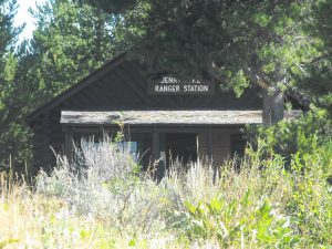
First, fly into Jackson, Wyoming airport. We used our credit card reward program miles to get there, so the cost was the redemption fee and giving up using the miles for another trip. Then, take a taxi to the Jenny Lake Ranger Station.
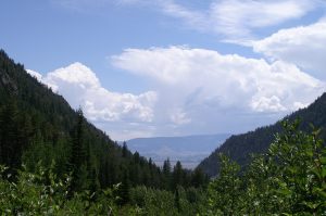
You have to go to the ranger station to get your backcountry permits, so while you are there get the permit and check into the backpackers campground. The campground for one night should run you about $8.00. The permit will cost you $35.00 regardless of how many nights you spend on the trail, so plan your trip to start with a walk up the Paintbrush from Jenny Lake. Your first night you’ll need a permit in the camping zones just east of Paintbrush Divide. This day hike should get you acclimated to the altitude because you’ll go over Paintbrush Divide at over 10000 feet into the North Fork of Cascade Canyon the next day, passing Lake Solitude.
Put the North Fork of Cascade Canyon on your permit for the second night and rest up to cross Hurricane Pass, also over 10,000 in elevation on the third day.
The third day will take you into the Alaska Basin where a short day will give you plenty of time to set up camp near Sunset Lake and enjoy the backcountry. No permit is needed to camp in the Alaska Basin as it is not in the Grand Teton National Park. Accordingly, you may have a number of campers around you instead of the solitude you get in the Park.
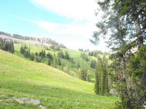
Leaving the Alaska Basin spend a day and a night on the Death Canyon Shelf or at Marion Lake, or if you don’t have time to relax on the trip, skip the night in the Basin and spend the third night on the Shelf.
Looking toward Mt. Meek from Death Canyon Shelf
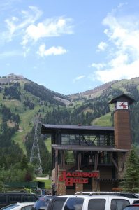
From the Shelf, you’ll go down past Marion Lake and pick up the trail up Rendezvous Mountain to the top of the TRAM, also above 10,000 feet. The Tram will take you down to Teton Village and there is no charge for the ride down. They only check tickets on the way up. If you ride up, it will cost you $35.00.
Tram
In the Village you can find low-cost accommodations at the Hostel. You can shower, shave, sleep and get ready to catch a shuttle to the airport, perhaps for as low as $3.
So, there’s your itinerary for the budget trip. Remember that the permits are limited and in short supply so you might want to try to secure them online before you go. This trek should be made in August or early September, so try to get your permits at recreation.gov between the preceding January 1 and March 15. You will still have to pick the permit up at the Jenny Lake Ranger Station when you get to Jackson Hole.
What will the trip cost you? Your airfare or credit card miles, one way taxi fare, $8.00 to camp at Jenny Lake, $35.00 for the backcountry permit, your night at the Hostel, the cost of the shuttle to the Airport and whatever food you eat. For a trip of a lifetime, that is a bargain. Of course, you’ll have to come back on another trip to explore the rest of Jackson Hole.
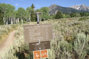
When my spouse came home from a hike to Len Foote Inn gushing with excitement over the photographs a fellow backpacker had shared about the Grant Teton National Park, it took no encouragement to convince me to revisit one of the places I had seen as a teen. The next few posts will chronicle our backpacking trip and then I’ll tell you how to backpack the Grand Teton on a real budget. Lets begin at the Granite Canyon Trailhead.
Granite Canyon Trailhead
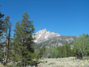
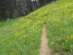
In the backcountry we didn’t see a lot of people, but many of the backpackers and trail runners we encountered were starting at the top of the Tram in Teton Village. We thought we’d get better acclimated to the altitude, which varied during our trek from about 6500 to 10400 feet above sea level, by walking up the Granite Canyon Trail past Marion Lake to the Death Canyon Shelf. It was a great decision because the Granite Canyon Trail should not be missed when wild flowers are in bloom.
The trailhead is inside the Grand Teton National Park, about three miles north of Teton Village on the Wilson-Moose road. Because we didn’t want to pay to leave a rental car sitting at the trailhead and because we weren’t making a loop, we hired OLD WEST Transportation in Jackson to take us to the trailhead.
Near Trailhead
Initially, the trail starts off toward Granite Canyon by passing through a sagebrush meadow with a number of birch trees along the way, however Granite Canyon Trail has many personalities.
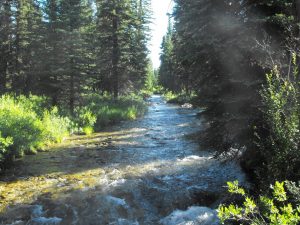
Creek
Before too long we cross a small bridge over Granite Creek which flows through the canyon. As you might expect, Granite Canyon Trail somewhat parallels the creek but doesn’t follow the bank of the creek. Once into Granite Canyon, you soon come to one of three camping zones designated by the Park Service. As with all the backcountry controlled by the National Park Service, you will need to get a permit for overnight camping. The first is the Lower Granite Canyon Zone and runs for about three and one half miles along the canyon. In this zone, the designated camping sites are numbered with small signs adjacent the trail and short side trails leading to the individual campsites and the one group campsite. The campsites are well spread out and there is no problem with neighbors being too close.
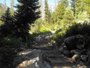
We shortly begin our acclimation to the altitude and the weight of our backpacks. This was an unsupported trip, so we had everything we needed for five days on the trail on our backs. Our acclimation began as the trail began to rise and change.
The birches faded away and the trail side became more forested with evergreens. We were expecting to gain 2000 to 2500 feet in elevation on the way to our first campsite and we weren’t disappointed. The well used trail had improvements like the set of steps we encountered as the trail began to rise and change. Did I mention bears? Apparently, the bears are quite active, so when we got our permits from the Jenny Lake Ranger Station, we were required to carry bear canisters, in which all of our food had to be stored. It took some reconfiguring of the backpacks to get these inside with the food in them.
Bear Canister
I mention that because as we got further from the trailhead, we realized that the possibility of bears was quite real. In addition to keeping the food in the canisters, we each were dutifully equipped with our bear strength pepper spray and one of us wore a bell, which we allowed to jingle when we were passing though heavy growth. Of course, Granite Canyon trail didn’t stay the same so the bell didn’t always ring.
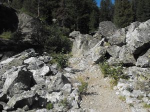
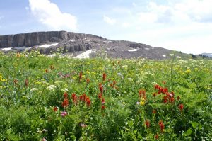
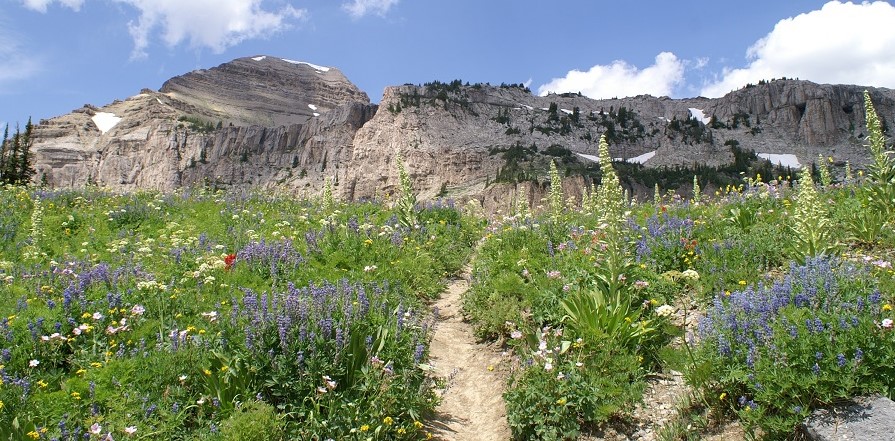
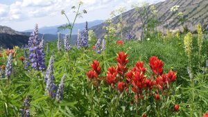
Just a little further down the trail, it veered away from the creek and took us through a boulder field. As always, we’re thankful for those who laid the trail out and cleared a path across these boulders to the next stretch of soil. That stretch of soil gave us our first real look at the wild flowers found along Granite Canyon trail.
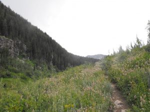
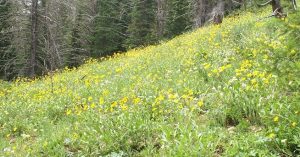
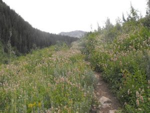
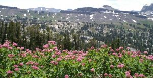
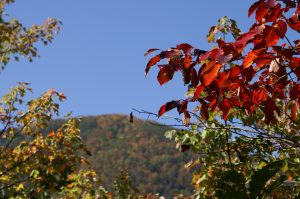
Our circuit took us past some amazing sights including some that took your breath away, but nowhere along our hike did we find wildflowers as gorgeous as we saw in the first two days. The yellow ones you can see in the picture above were dominant early in the hike but as you’ll see in our post on the Wildflowers of the Grand Teton, the colors along the trail matched the rainbow.
Trail through Evergreens and flowers
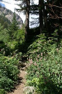
The yellow flowers gave way, temporarily to thicker brush with light lavender blossoms and the vegetation changed back from meadow to forest. Of course we are going ever higher in elevation and beginning to breathe a little heavier. One of the great rules of hiking is to always remember to look behind you and when we did, we realized why our breathing was a little labored even though the rise seemed gentle.
Looking back down Granite Canyon
After just a couple of hours, looking back down the canyon toward the trailhead brought an instant smile from the fact that we had already gained so much in elevation. There was a lot more elevation to come, but at this point the joy of being on the trail in a beautiful setting made us think we’d risen to the clouds.
Toward the end of the day, we reached a divide in the trail with the left fork leading to the South Granite Canyon Camping Zone and the right leading to the Upper Granite Camping Zone. We took the fork to the right as our permit was for the Upper Granite zone. This zone is not as long and the sites are not designated by signage, except for the group site and the horse site, but rather are recognized by the recommended repeated usage of an older site to avoid creating numerous open areas for camping. The sites are easily identified as they are relatively near the trail and have clearly defined side trails leading to them.
We didn’t venture into the South Granite Canyon Camping Zone, however the trail through there leads to a trail to the top of Rendezvous Mountain and the Tram before rejoining the Upper Granite trail for the ascent to Marion Lake.
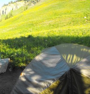
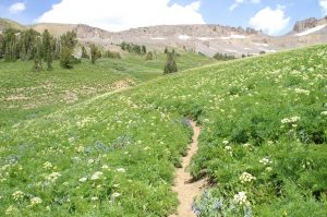
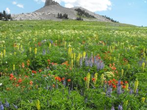
At the end of the Upper Granite Canyon camping zone, the trail comes to the meadow pictured above. The meadow was filled with the yellow flowers such that it changed color in the morning. We stopped at the last campsite in the zone, which was about 75 yards from the end of the zone and adjacent the creek. What we didn’t know that the three campsites at Marion Lake, which is about a mile further into the back country, sit on this side of the lake and are elevated by about 1000 feet looking out over the meadow. The next morning, we met a party that had hiked from the Tram to Marion Lake to spend the night and was headed out down Granite Canyon Trail. They told us that they had been amused by watching us scurrying about in the meadow, setting up our camp and what not.
Last site in Upper Granite
We were not phased by their comments and agreed that we had just been happy to reach the campsite after about seven and one half miles of backpacking uphill along the beautiful Granite Canyon Trail.
Our next section of the trail takes us past Marion Lake onto the Death Canyon Shelf.
The images of the wildflowers in this post were taken during our backpacking vacation trek in the Grand Teton from Granite Canyon Trailhead to Jenny Lake. No more words, just images and captions.
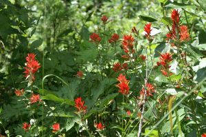
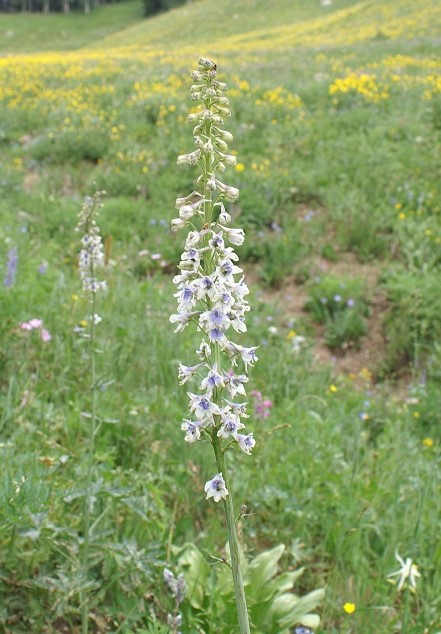
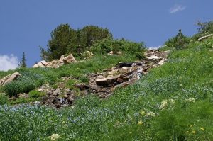
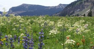
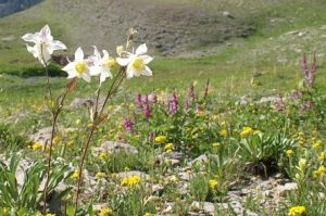
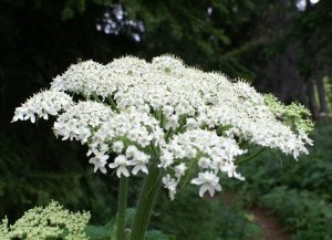
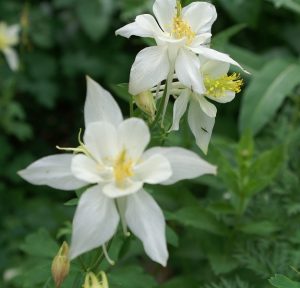
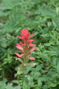
Teton’s rainbowA patch of colorThis delicate bloom grows along the trail in the Grand Teton National Parkblue flowers uphillIn the meadowThe trail runs through the wildflowers in Grand Teton NPColor assortmentCascade whiteWhite bloomsPaintbrushGranite Canyon transitionA trail runs through a sea of yellow in Granite CanyonYellow carpet in the canyonpink border along the trailBright colorsCascade Canyon fernsCascade Canyon MeadowFlowers in the Alaska BasinA pink border for the Alaska BasinAbove MarionAbove Lake MarionAbove Death Canyon
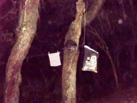
We returned to Cumberland Island for another back country adventure and naturally took a little too much food with us. We could have eaten it all but we didn’t. We took our usual GRUBPACK back country food sack made of metal mesh with a heavy-duty hook and loop closure to put the food, pots, plates, and toiletries in to keep the raccoons and squirrels from destroying our tent or backpack. We strung the GRUBPACK sack between two limbs but over the course of a couple of days it moved a little too close to one of the trees.
About 4 am in the morning, Mary shook me saying ” There’s something after the food!” The rattling of the pot and lid in the sack had awakened her. Shining her headlamp out the tent toward the food she started yelling “Hey! Go away!” Then muttered “raccoon.” I had gotten to the door and saw the little culprit tugging on the rope and trying to grab the bag. I got out of the tent with my headlamp and picked up a hiking pole to flail around with. At first he ignored me, but then crawled down the tree and retreated a few yards into the palmetto fronds where his yellow eyes gave proof that he wasn’t leaving.
After checking the integrity of the bag, I crawled back into the tent. Before I could settle in, the pot was rattling again. We decided he couldn’t get to the food and if the bag fell, it would still be tied to one of the trees so we just let him work at it. About an hour later the sound stopped. At sunrise the bag was still hanging, intact with all our food and gear no worse for wear.
We did our annual fall hike up Mount LeConte in the Great Smoky Mountains National Park . We may only make one hike up next year as we didn’t get a reservation at the lodge for the fall in the lottery. For those who may not know, the picture below shows Mt. LeConte from a cabin we rented just above Gatlinburg.
Mt. LeConte
The lodge on top is between the two major peaks just to the right of the group of three peaks. I’ll just caption the pictures and tell you the story in another post.
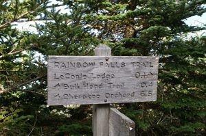
He was actually at the bottom of Rainbow Falls trail
along the trail
Fall foliage
Leaves on LeConte
The leaves were peak
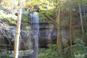
Waterfall
Here are the falls.
A welcome sight!
Easy Street
The marker you’ve been waiting for.
Trail choices
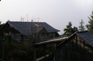
The lodge office and lounge
LeConte Office
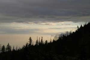
Morning sky.
Morning on LeConte
All of these pictures were taken by Mary. She just lets me use them for your enjoyment.
Our little group just finished another hike to Mount LeConte near Gatlinburg, Tennessee, USA. I’ll post all the details later, but I wanted to share a part of the trip with you in a condensed version. We were at the top of Mt. LeConte for two nights spending the entire day there on April 27. As usual the weather was changeable. We had hiked up in a thunderstorm on the 26th and had intermittent clouds and sunshine most of the 27th.
The dining hall at LeConte Lodge
As you can see above the day started off with clouds. It was somewhat humid, but the temperature by afternoon was in the mid 50’s Fahrenheit. Our intention was to spend the day hiking around the top of Mount LeConte and taking it easy. We had come up Alum trail again which is a fairly strenuous trek, particularly in the rain of a thunderstorm. We wanted to go over the top of the mountain to Myrtle Point, which affords the best views of sunrise on Mount LeConte, to spend an hour or two in the afternoon resting on the rocky ledge looking out over the Great Smoky Mountain National Park. As we pushed along we soon saw an unmistakable image of why these mountains are called the Smokies.
The mountain billowing smoke
Looking at the above picture, the view is along a ridge that runs south from Mount LeConte. The Boulevard trail follows this ridge from LeConte to the Appalachian Trail. The wind is from the west, or moving from right to left in the picture. As the wind rises up from rises up from the valley to the crest of the ridge there are no clouds to the west, but as soon as the wind crosses the ridge, clouds boil up from the east side like smoke from a volcano, creating a vision of smoke rising out of the ground. After a couple of hours it diminished, but it was an amazing sight while it lasted.
A view from Myrtle Point.
On Myrtle Point, even with the Smokies haze, the view is what you go to the mountains for. Although, you might see something similar from a car, there is nothing like getting to the top of a 6000 foot mountain on your own feet and taking your shoes off while resting in the sun and the clouds. Yes, sometimes you are in the clouds. Myrtle Point juts out into space and is a granite point surrounded by low growing Myrtle shrubs. It is accessible only by walking at least six and a half miles up and over Mount LeConte or by hiking over seven miles from Newfound Gap along the Appalachian and Boulevard trails. Thus, the view above is not a sight everyone will see with their own eyes. You should try though, because it is incredibly peaceful and restful, to sit there and look out at the mountains and the ever-changing sky.
Near the crest of Mount LeConte, along the Boulevard trail, there is an Appalachian Trail through hiker shelter that gives the through hikers a respite if they decide to take Boulevard to LeConte and then venture down into Gatlinburg. Since our last visit to LeConte about 6 months ago, the National Park Service installed a new composting toilet for the use of the through hikers. It seems to work well, but like every thing else I’ve been talking about. It’s up hill to get there. In fact, at the bottom of the Alum Cave trail the National Park Service erected this sign which has warnings to hikers to take precautions
National Park Service Trail Map and Warning
because of the footing. The sign states, in part: “This trail is steep and rocky. Wear sturdy boots with adequate ankle support.” Further, if you look closely, you will see that the sign also indicates that the summit is over five miles away, at over 6,500 feet and takes four of five hours of hiking to reach.
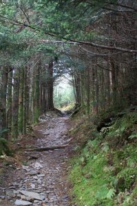
An easy part of the Alum Cave Trail
The part of the trail shown above is in the lower half of the trail. As I stated earlier, the new composting toilet at the through hikers shelter is near the summit of Mount LeConte and there is no way to get there, except on the trails. So, take a look at what the National Park Service installed for the through hikers to use.
ADA toilet at 6500 ft elevation along a rocky trail at least six miles from the nearest road.
They have their very own Americans with Disabilities Act approved toilet. I have carried a back pack up or down every trail leading to this toilet on all sides of Mount LeConte. I guarantee you that any person who required such a toilet as part of his/her normal life would not be able to roll their wheel chair to this toilet, even if you carried them to a spot within a quarter of a mile from the toilet. At Goneguru, we want everyone to have a quality life and to enjoy travel and the great outdoors. We support research for such disabling diseases as Multiple Sclerosis, but some things just don’t make sense. If you can explain to me the logic in why this toilet was configured to be ADA approved, please do so.
The Great Smoky Mountains National Park didn’t exist before the Great Depression. Chartered in 1934, the park took in over 800 square miles in eastern Tennessee and western North Carolina. 10 million visitors per year pass through the park, with a large number of them passing along US highway 441 between Gatlinburg, Tennessee and Cherokee, North Carolina. To the east of this main tourist area, just north of Maggie Valley, NC and just off of I-40 is the Cataloochee.
Settled by white men who gradually displaced the Native Americans between 1800 and the Civil War, the Cataloochee as it is today gives a glimpse of life in the remote valleys of Appalachia at the turn of the twentieth century. The settlers descendants were themselves displaced by the creation of the park, leaving behind their houses, barns, fields, churches and cemeteries. When you go there you will feel the shadows of both the Native Americans and the white settlers, or maybe you’ll just feel the wonderful remoteness and stillness of the place. Getting there is not difficult, but don’t expect to roll in your RV; you can’t get them around some of the curves in the road. For an idea of what the road in is like you might want to take in a video someone posted on You Tube.
The campground is located on the banks of one of the streams flowing through the valley and like most National Park Service campgrounds charges a modest fee for a reservation which can be made online up to 6 months in advance of your trip. It is perfect for car campers who want to unload their gear from the back of the car onto the picnic table and sort it out from there. Bathhouses with shower are there, but note that the last time we were there, the filtration system was not working so take along a water purification system or plan to boil all the water you intend to consume.
If you proceed down the road a few yards past the campground, you’ll find the trailhead for the Boogerman loop trail. The trail climbs the mountain on the side of the valley and comes back down to the stream. Along the stream you’ll find yourself walking across a dozen or more log bridges.
A typical Cataloochee footbridge
Along this part of the trail, you will share space with horseback riders, but up on Boogerman loop proper you won’t see any horses. What you will find are some of the foundations of the houses of the farmers who cleared the fields on these mountains and maybe a little rusted tin from the roof of one or two. You may even feel as though you are trespassing, walking through a forest regenerated from a field cleared with back-breaking work. Along the way you will come to a low wall, three to four feet high and three feet wide stretching for a hundred yards into the forest. Most likely, as the field was cleared and plowed, the rocks in the wall were unearthed and carried to the edge of the field, where they were laid into an orderly wall. As you can see, in the 85 + years since the Park took over the farms, along these hillsides the forest has reclaimed fields.
Something in the earth doesn’t like a wall
Look for the giant Poplar tree near the wall. Its base is hollow and two of us stood inside it. These giants haven’t been seen by everyone. I could post a picture, but you need to go see it for yourself.
The trail comes back down the mountain past the old farms and rejoins the stream. If you went along Boogerman loop clockwise, you’ll turn to the right to get back to the trail head. As we did so, we soon encountered where the forest had tried to reclaim a footbridge. We made it across, and as you see it was gracefully done.
Footbridge 8, too far along to go back
Back at the trail head you can turn left and drive or cycle a few miles down into the valley where the meadows still grow tall grasses. You’ll likely see turkey or deer or, if you are out early in the morning or just at dusk, you may encounter a herd of Elk. Once native to these mountains, a re-population project was started a few years ago with 25 Elk. From what we have seen the project has been a success and Elk can be found over a wide area of the National Park. We intentionally went to the meadow at dusk and were literally surrounded by Elk. Although they know they have to share the meadow with mankind, they remain nervous creatures, so don’t get too close. They are wild and deserve their space.
Part of the herd in the meadow by the schoolhouse
If you take the road on down past the bridge and the school-house you’ll come to a farm-house and its barn. Get out and go into both. Sense the presence of a time long gone. It reminded me of my grandparents farmhouse that was built about the same time. I’ll come back with another post about the houses, barns, churches and schools left behind and the Elk who have returned.
In the summer of 1967, two young women were killed by separate grizzly bear attacks on the same night in Glacier National Park. When you hike or backpack the Highline Trail to Granite Park Chalet you will be visiting the site where one of the incidents took place. Prior to that time, watching the grizzlies forage through the trash and food scraps discarded by the Chalet into a nearby ravine was considered suitable amusement for the overnight guests at the Chalet. In fact the Chalet had even set up lights in the ravine so that the guests could see the bears better. The entire story of the night is told in the book The Night of the Grizzlies by Jack Olson.
Granite Park Chalet from across the feeding ravine
We began our hike to Granite Park Chalet at the intersection of the Highline Trail and the Going to the Sun Road at Logan Pass. Although it was July, you will see snow in pictures and the road, which traverses Glacier National Park, had only opened in late June. Glacier sits astride the Continental Divide and the water from the winter snows flows east to the Gulf of Mexico, west to the Pacific Ocean, and north to the Hudson Bay. The Highline Trail hugs the sky just below the Contiental Divide. As you begin hiking you are on a narrow ledge of a trail across the Garden Wall and at times feel suspended between heaven and earth, but the trail is mainly level without significant changes in altitude, so the walk is exhilerating. You are hiking at about 8000 feet above sea level almost all the time.
Looking down on Going to the Sun Road from the Garden Wall
Mary, the Seer, takes all the great photographs in this blog and with her camera in her hand she knows no fear. Neither height, nor wind, nor wild animal can deter her from getting that shot. Along the Highline, we had all of the above. After hiking for a while, we came to a pass that was still covered with snow, but it had melted down to where the snow was only about a foot deep and had become well packed. We carefully picked our way across the snow circling around a projecting formation known as Haystack Butte. As we made our way between the high ground of the Continental Divide to our right and Haystack Butte, Mary whispered, “look!” Before I could say be careful, she had slid her backpack to the ground and had the lens cap off her camera, already walking across the packed snow toward the long slide down to the Going to the Sun road. And there, right in her viewfinder was the magnificent Bighorn Ram in the picture below.
Bighorn Ram on the slippery slope
The ram was, of course, too smart to really get himself into danger, so after a moment of teasing eternity, he turned and walked back toward the area where the snow had melted, never in a hurry and never showing any real concern for the hikers. Finally, he turned and posed for Mary to get the shot she wanted, and we moved on down the trail.
His Majesty
Granite Park Chalet is about 7 to 8 miles along the trail from Logan Pass and the picture below is probably close to half way there. It was along here that we encountered the first of many mountain goats. Each was a female with a kid. The kids, in each instance only a few weeks old, skipped over the steep slope as if it were a living room carpet. Of course, while the kid was playing at a distance Mary got up close and personal with the mama’s. As you can see, the mama has a face only a kid could love.
Mama Goat losing her coat
The Highline Trail is above the tree line here so the veiws are more than spectacular. They don’t call Montana the Big Sky Country for nothing. As you walk along you can’t keep your eyes on the trail because the vistas draw you into some quietly peaceful place. The sound of the cars churning up the road were gone long before we reached Haystack and here you are alone with who ever you are hiking with and God’s creation.
Looking down the valley toward Lake McDonald
More than a mile from Granite Park Chalet we can see the building sitting on a ridge jutting out into the valley. As with most hikes, it seems tantalizingly close and infinitely far away after you’ve already walked nearly 7 miles in splendid unbelievable air. Amazingly, we had beautiful blue sky as well as the sure threat of rain, which came and went in a matter of minutes dropping the temperature at least 20 degrees. A sign that, at this elevation, change is constant, rapid and certain. As we walked across the yard to the Chalet, we passed an offset room to the back of the building. In the 1920’s when the Chalet offered full service to its guests, this room had held the meat and other provisions. Notice the spikes on the shutters. Where people are, bears follow.
A shuttered window with anti-bear spikes at Granite Park Chalet
As I understand it, Granite Park Chalet and Sperry Chalet as well as the Great Lodges at Glacier National Park were built by the Railroads in their heyday between 1912 and 1920 to attract tourists who would take the train to Great Lodges and then travel to the Chalets on horseback. At that time, meals were prepared for the guests and a larder was stocked for their pleasure. Now, there is a kitchen which is available for you to use to cook what you carry and bunk beds in common rooms for you to sleep in. The cooks and other servants have been gone for decades. The view is as beautiful as ever.
Part of the view from the front porch of Granite Park Chalet.
Although the two bears responsible for the deaths in 1967 were euthanized, there are still plenty of grizzly and brown bear in Glacier. We saw a couple of grizzly through a telescope mounted on the porch at the chalet. We happened to be looking back along the Highline and saw the bears down in a meadow below it. On a hike further west, which I’ll tell you about in the next Glacier post, we saw where the grizzlies had churned the ground looking for food. As you might have expected, no one feeds the bears at Granite Park Chalet, and when you cross the ravine where the feedings once took place, it is impossible to not look over your shoulder.
Although Cumberland Island is a National Seashore, there is no bridge to get there, and we all like it that way. This treasure is the southernmost barrier island off the coast of Georgia (USA) at the mouth of the St. Mary’s River. Although inhabited for thousands of years, since the 1970’s most of the island has been under the control of the National Park Service which limits the number of visitors to the island to about 300 per day. The island is 17 miles long and 3 miles wide, so there is plenty of room to separate yourself from the crowd. Technically, there are some private landowners remaining on the island who are heir’s of the Carnegie’s and other long gone islanders, whose history is chronicled in the book Strong Women, Wild Horses, among others. I’ll only touch some of the island history to help you understand the place before you make your visit.
Other than the few private landowners and the Park Service employees, there are no vehicles allowed on the island, thus, for those of us who like hiking in serene silence away from the world, this is one of the places where most of the time you’ll be satisfied with what you hear. One shell packed road runs the length of the island and the eastern side of the island beaches on the Atlantic Ocean, so the beach is immense and virtually deserted.
Stafford Beach on Cumberland Island
The picture above is of the beach three miles from the ranger station. You can get there by walking or renting a bicycle and cycling along the road. Otherwise, you won’t see it. There are no developments on the beach and access across the dunes to the beach is restricted to a dozen or so well marked lanes. So, how do you really get to this reclaimed beauty? Read on.
If you have a private vessel capable of navigating the intercoastal waterway, you can get to Cumberland Island by yourself, but most of us rely on the ferry which is authorized by the NPS to carry visitors from the dock at St. Mary’s, Georgia to Seacamp dock on Cumberland Island. The ferry runs twice a day, once in the morning and once in the afternoon and takes about 45 minutes to get to make the trip. Pay attention to your return trip departure time because, although they count heads on the way to the island, they have no way of knowing how many are supposed to be on the boat on the way to the mainland, therefore, they don’t try to account for your return. There are also no provisions available on the island, so take your own water and food or buy some on the ferry. If you are making a day trip and want to rent a bicycle, you have to do it on the ferry. If you are staying overnight and want to buy firewood, the only place you can do that is on the ferry.
Once you are on the island, the choices and the distance between choices make the decisions for you. We wanted to backpack to Stafford Beach and camp at the campsites there. Another group that ferried over with us had young children and were headed to the campsites at Seacamp. A young couple on the ferry were backpacking a couple of miles beyond Stafford Beach and camping at an even more remote backcountry campsite. As you
Boardwalk over the dunes to the beach at Seacamp.
guess, each option had its advantages and drawbacks. Seacamp is the closest to the dock and ranger station and about 1/2 mile along a sandy trail across the island. A number of campsites are arranged for substantial privacy and the campsite has running water, showers, toilet facilities and a group area. The boardwalk shown above leads from Seacamp over to the beach. You will have miles of beach in either direction, but you will be sharing it with the largest concentration of people on the island. Stafford beach is 3 and 1/2 miles from the dock along the parallel trail which is well-marked.
Parallel Trail to Stafford Beach
The trail more or less parallels the road, but is a far more enjoyable and easier hike. The trail cuts through the palmetto fronds beneath the live oaks and you soon lose sight of the road or where you came from. Watch your step because wild horses and wild hogs share the trails with you and leave their souvenirs along the way. As plentiful as the dung was, we never saw the hogs, although the population is such that the NPS has had to institute hunts to thin the herd. The twisted shapes of the live oak trees, the leaves filtering the sun and the limited distance visibility give the landscape along the trail a mystical and unreal quality. You would not be in the least surprised to see any creature from folklore stick his head around a tree and look at you . In all likelihood, you will see the wild horses on the island. They run free on the island at the command of Ms. Lucy Carnegie, grand dame and matriarch of the island’s Carnegie clan, as set forth in her will decades ago. At the time of the American Revolution, the live oaks were harvested for use in the sailing vessels of the day because of their great strength and resiliency. Barrier island oak was used in the USS Constitution and can be seen today if you visit the ship in Boston.
When you arrive at Stafford Beach camp, you can select from one of less than 20 campsites equipped with a fire ring. There is a common bathhouse with a cold water shower and toilets, however, any water from the area including the bath house has to be treated by boiling, filtering or chemicals before it can be consumed. Don’ t even brush your teeth with untreated water. Your campsite can range from extremely private to rather private depending on the proximity to the bathhouse. A trail runs across the dunes to the beach pictured at the top of the post. Although the rangers sometimes drive over to check on things, the only other people you will see on this beach are the ones who have hiked three plus miles to get there. They are there for the same reason you are: and that is nobody’s business.
Stafford Beach campsite
We chose a campsite away from the bath house and away from the beach. As you can see it was great. We used the overhanging trees to suspend our supplies so the raccoons, squirrels and hogs couldn’t get into it. Note that firewood is scarce and you may want to bring a lightweight cutting implement to reduce what you may find to fit into the fire-ring. The campsites north of Stafford Beach are primitive. There are no bathouses and no potable water. These campsites are also not near the beach and at least one is on the intercoastal waterway side of the island. We haven’t made it to one of those yet, but the young couple we met came back smiling.
If you want to see the island and its history in a short amount of time, then you should take the tour. Fifteen passenger vans leave from the ranger station at the dock twice a day to take you on the tour. We walked the three and 1/2 miles back to the ranger station one morning to take the tour, only to learn that you have to by the tickets for the tour on the mainland before you get to the island. Be prepared. We walked the 7 & 1/2 half miles to Plum Orchard mansion, one of the many Carnegie mansions on the island and then the 4 miles back to Stafford Beach. It was worth the walk. A volunteer working in conjunction with the Park Service was at the mansion and gave us a great talk as he showed us around. A half mile or so south of the ranger station is the museum, housed in the Carnegie ice house and beyond that are the ruins of the main Carnegie complex, where Ms. Lucy held sway and before her the earlier claimants on this amazing island. Ms. Lucy’s Dungeness burned in the middle of the twentieth century but you can still sense its grandeur from the ruins.
Dungeness Ruins on Cumberland Island
At the north end of the island is the church where John F. Kennedy, Jr. got married, in between is the Greyfield Inn run by the Carnegie heirs, cemeteries, wild horses and maybe a few ghosts. Most of all it is a place to get away from it all. I’ll have more to say in a later post.
The National Parks are an amazing treasure. A Rocky Mountain National Park not be missed is Glacier National Park located in northern Montana. We probably have as many pictures taken in Glacier as anywhere we’ve visited. Words are not enough.


")
")


 of Copy of DSC00876")


