Did you know that on the fateful voyage of the Titanic in 1912, the Captain had altered course and was heading for Halifax, Nova Scotia to refuel instead of going straight to New York? We learned that by accident when in Halifax, when I insisted that we should go to the Maritime Museum on the waterfront in Halifax. It was against the wishes of the others in our traveling group, but I insisted that the Titanic exhibit shouldn’t be missed. I was, of course, right and, of course, wrong. The Titanic exhibit is but a small part of a wonderful museum that you should indeed see when you are in Halifax.
Parrot in the Pirate exhibit
Also not to be missed when you are in that part of the world is a trip to Peggy’s cove, small fishing village not far from Halifax with an amazing view and beautiful lighthouse that never was seen by the passengers on board the Titanic.
Lighthouse at Peggy's Cove
However, there are about 180 of the people who perished on the night the Titanic sank buried in Fairview Lawn Cemetary, there in Halifax. When the word went out that the great vessel was going down, Halifax was the nearest port and ships and boats from the port headed out to give aid and assistance in the rescue effort. The grim affair was of little use to the living, but many of the lost were plucked from the icy water and brought to rest in Halifax. In that day and age, it was not realistic to re-patriate the bodies of many who had been heading to America and a new life. So, their final resting place was in this cemetary.
A cemetary in Halifax
Here , the victims are laid out in orderly rows in the form of a ship’s bow. Those who could be identified have their names engraved in uniform stone markers. They lie here together, rich and poor, young and old, made equal in the sea. Even generations after the tragedy some still seek these to find out what happened to a family member or confirm some mystery from a story told somewhere in time. There are some gravestones that bear names we all know such as
J. Dawson, lost with the Titanic
No. He wasn’t Jack Dawson from the movie Titanic, but he was a real person who lost his life on that April night. So, why did my traveling companions not want to go to the Titanic exhibit and visit the cemetary where these poor souls rest?
We had come into Halifax as the first port of call on a Canada and New England Cruise, so we had to get back on the boat and go back out to sea directly from the cemetary!
The Great Smoky Mountains National Park didn’t exist before the Great Depression. Chartered in 1934, the park took in over 800 square miles in eastern Tennessee and western North Carolina. 10 million visitors per year pass through the park, with a large number of them passing along US highway 441 between Gatlinburg, Tennessee and Cherokee, North Carolina. To the east of this main tourist area, just north of Maggie Valley, NC and just off of I-40 is the Cataloochee.
Settled by white men who gradually displaced the Native Americans between 1800 and the Civil War, the Cataloochee as it is today gives a glimpse of life in the remote valleys of Appalachia at the turn of the twentieth century. The settlers descendants were themselves displaced by the creation of the park, leaving behind their houses, barns, fields, churches and cemeteries. When you go there you will feel the shadows of both the Native Americans and the white settlers, or maybe you’ll just feel the wonderful remoteness and stillness of the place. Getting there is not difficult, but don’t expect to roll in your RV; you can’t get them around some of the curves in the road. For an idea of what the road in is like you might want to take in a video someone posted on You Tube.
The campground is located on the banks of one of the streams flowing through the valley and like most National Park Service campgrounds charges a modest fee for a reservation which can be made online up to 6 months in advance of your trip. It is perfect for car campers who want to unload their gear from the back of the car onto the picnic table and sort it out from there. Bathhouses with shower are there, but note that the last time we were there, the filtration system was not working so take along a water purification system or plan to boil all the water you intend to consume.
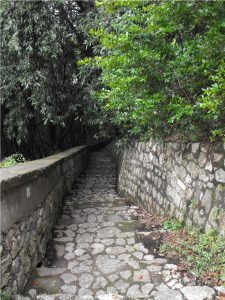
If you proceed down the road a few yards past the campground, you’ll find the trailhead for the Boogerman loop trail. The trail climbs the mountain on the side of the valley and comes back down to the stream. Along the stream you’ll find yourself walking across a dozen or more log bridges.
A typical Cataloochee footbridge
Along this part of the trail, you will share space with horseback riders, but up on Boogerman loop proper you won’t see any horses. What you will find are some of the foundations of the houses of the farmers who cleared the fields on these mountains and maybe a little rusted tin from the roof of one or two. You may even feel as though you are trespassing, walking through a forest regenerated from a field cleared with back-breaking work. Along the way you will come to a low wall, three to four feet high and three feet wide stretching for a hundred yards into the forest. Most likely, as the field was cleared and plowed, the rocks in the wall were unearthed and carried to the edge of the field, where they were laid into an orderly wall. As you can see, in the 85 + years since the Park took over the farms, along these hillsides the forest has reclaimed fields.
Something in the earth doesn’t like a wall
Look for the giant Poplar tree near the wall. Its base is hollow and two of us stood inside it. These giants haven’t been seen by everyone. I could post a picture, but you need to go see it for yourself.
The trail comes back down the mountain past the old farms and rejoins the stream. If you went along Boogerman loop clockwise, you’ll turn to the right to get back to the trail head. As we did so, we soon encountered where the forest had tried to reclaim a footbridge. We made it across, and as you see it was gracefully done.
Footbridge 8, too far along to go back
Back at the trail head you can turn left and drive or cycle a few miles down into the valley where the meadows still grow tall grasses. You’ll likely see turkey or deer or, if you are out early in the morning or just at dusk, you may encounter a herd of Elk. Once native to these mountains, a re-population project was started a few years ago with 25 Elk. From what we have seen the project has been a success and Elk can be found over a wide area of the National Park. We intentionally went to the meadow at dusk and were literally surrounded by Elk. Although they know they have to share the meadow with mankind, they remain nervous creatures, so don’t get too close. They are wild and deserve their space.
Part of the herd in the meadow by the schoolhouse
If you take the road on down past the bridge and the school-house you’ll come to a farm-house and its barn. Get out and go into both. Sense the presence of a time long gone. It reminded me of my grandparents farmhouse that was built about the same time. I’ll come back with another post about the houses, barns, churches and schools left behind and the Elk who have returned.
In the summer of 1967, two young women were killed by separate grizzly bear attacks on the same night in Glacier National Park. When you hike or backpack the Highline Trail to Granite Park Chalet you will be visiting the site where one of the incidents took place. Prior to that time, watching the grizzlies forage through the trash and food scraps discarded by the Chalet into a nearby ravine was considered suitable amusement for the overnight guests at the Chalet. In fact the Chalet had even set up lights in the ravine so that the guests could see the bears better. The entire story of the night is told in the book The Night of the Grizzlies by Jack Olson.
Granite Park Chalet from across the feeding ravine
We began our hike to Granite Park Chalet at the intersection of the Highline Trail and the Going to the Sun Road at Logan Pass. Although it was July, you will see snow in pictures and the road, which traverses Glacier National Park, had only opened in late June. Glacier sits astride the Continental Divide and the water from the winter snows flows east to the Gulf of Mexico, west to the Pacific Ocean, and north to the Hudson Bay. The Highline Trail hugs the sky just below the Contiental Divide. As you begin hiking you are on a narrow ledge of a trail across the Garden Wall and at times feel suspended between heaven and earth, but the trail is mainly level without significant changes in altitude, so the walk is exhilerating. You are hiking at about 8000 feet above sea level almost all the time.
Looking down on Going to the Sun Road from the Garden Wall
Mary, the Seer, takes all the great photographs in this blog and with her camera in her hand she knows no fear. Neither height, nor wind, nor wild animal can deter her from getting that shot. Along the Highline, we had all of the above. After hiking for a while, we came to a pass that was still covered with snow, but it had melted down to where the snow was only about a foot deep and had become well packed. We carefully picked our way across the snow circling around a projecting formation known as Haystack Butte. As we made our way between the high ground of the Continental Divide to our right and Haystack Butte, Mary whispered, “look!” Before I could say be careful, she had slid her backpack to the ground and had the lens cap off her camera, already walking across the packed snow toward the long slide down to the Going to the Sun road. And there, right in her viewfinder was the magnificent Bighorn Ram in the picture below.
Bighorn Ram on the slippery slope
The ram was, of course, too smart to really get himself into danger, so after a moment of teasing eternity, he turned and walked back toward the area where the snow had melted, never in a hurry and never showing any real concern for the hikers. Finally, he turned and posed for Mary to get the shot she wanted, and we moved on down the trail.
His Majesty
Granite Park Chalet is about 7 to 8 miles along the trail from Logan Pass and the picture below is probably close to half way there. It was along here that we encountered the first of many mountain goats. Each was a female with a kid. The kids, in each instance only a few weeks old, skipped over the steep slope as if it were a living room carpet. Of course, while the kid was playing at a distance Mary got up close and personal with the mama’s. As you can see, the mama has a face only a kid could love.
Mama Goat losing her coat
The Highline Trail is above the tree line here so the veiws are more than spectacular. They don’t call Montana the Big Sky Country for nothing. As you walk along you can’t keep your eyes on the trail because the vistas draw you into some quietly peaceful place. The sound of the cars churning up the road were gone long before we reached Haystack and here you are alone with who ever you are hiking with and God’s creation.
Looking down the valley toward Lake McDonald
More than a mile from Granite Park Chalet we can see the building sitting on a ridge jutting out into the valley. As with most hikes, it seems tantalizingly close and infinitely far away after you’ve already walked nearly 7 miles in splendid unbelievable air. Amazingly, we had beautiful blue sky as well as the sure threat of rain, which came and went in a matter of minutes dropping the temperature at least 20 degrees. A sign that, at this elevation, change is constant, rapid and certain. As we walked across the yard to the Chalet, we passed an offset room to the back of the building. In the 1920’s when the Chalet offered full service to its guests, this room had held the meat and other provisions. Notice the spikes on the shutters. Where people are, bears follow.
A shuttered window with anti-bear spikes at Granite Park Chalet
As I understand it, Granite Park Chalet and Sperry Chalet as well as the Great Lodges at Glacier National Park were built by the Railroads in their heyday between 1912 and 1920 to attract tourists who would take the train to Great Lodges and then travel to the Chalets on horseback. At that time, meals were prepared for the guests and a larder was stocked for their pleasure. Now, there is a kitchen which is available for you to use to cook what you carry and bunk beds in common rooms for you to sleep in. The cooks and other servants have been gone for decades. The view is as beautiful as ever.
Part of the view from the front porch of Granite Park Chalet.
Although the two bears responsible for the deaths in 1967 were euthanized, there are still plenty of grizzly and brown bear in Glacier. We saw a couple of grizzly through a telescope mounted on the porch at the chalet. We happened to be looking back along the Highline and saw the bears down in a meadow below it. On a hike further west, which I’ll tell you about in the next Glacier post, we saw where the grizzlies had churned the ground looking for food. As you might have expected, no one feeds the bears at Granite Park Chalet, and when you cross the ravine where the feedings once took place, it is impossible to not look over your shoulder.
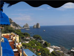
Our Italian hiking trip to Capri found us staying on the southern side of the Island at Marina Piccola. Although there are many fine hotels in the town of Capri, which sits astride the middle of the Isle de Capri, we chose to stay at the Hotel Ambassador Weber, mainly because it was right on the sea, which I prefer and because it was reasonably priced. Our window did indeed look over the sea, the beach below, to our left the Faraglioni and to our right the cliffs rising up to Mt. Solora.
The view from the Ambassador Weber
The staff at the hotel were very friendly and always tried to help, even pointing out trails along the map of Capri that they provided, however, when we told them that we wanted to walk up La Scala Fenicia, the concierge looked at us with dismay and exclaimed, “Oh no, it is very tiresome. You do not wish to do this!” We persuaded him that we did indeed want to go see the staircase, but we did not tell him that we intended to go all the way to the top of Mt. Solora, so he directed us to the other side of the Isle de Capri to Marina Grande, where the staircase begins a few feet above sea level.
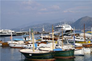
To get to Marina Grande from Marina Piccola, we walked up a brick pathway to Capri and then took the funicular railway, an inclined railway running between Capri ad Marina Grande. If you go to the Isle de Capri, your trip is not complete without riding it. From the Funicular we walked past the beach and docks up the road to the west of
Boats at Marina Grande
the fishing boats, then turned south with the street until we came to a small sign near the Church of St. Constanza marking the bottom of La Scala Fenicia. The staircase has approxiamtely 900 steps cut into the granite from the port to the town of Anacapri. For centuries, this staircase was the only way to get from the port to Anacapri. Although the name implies that the steps were cut by the Phonecians, they are likely to have been hewn by the Greek settlers of the island instead.
The climb takes you past the residences, school, and olive gardens and fields. As you look back down the steps, the fishing boats in the marina grow increasingly smaller and the climb becomes steeper and steeper. You look up to see where the staircase may come out and wonder if you can get there. Eventually the trail crosses the modern road to AnaCapri, and as you walk from beneath the roadway people look at you as though you were insane. It is probably the fact that your mouth is hanging open gasping for air. Above the road the steps continue, and the panorama below you grows ever larger until you come to Villa San Michelle, built by Axel Munthe and now a museum. There, you find yourself on a street passing little shops and leading into Anacapri.
La Scala Fenicia above the road
We walked through the town and found our way to the Church of St. Michele. The floor of the church is a hand painted tile depicting the explusion of Adam and Eve from the Garden of Eden. Walkways around the floor preserve its beauty and allow you to see it up close, but you won’t appreciate it until you climb the staircase and look down from the galleries above. We returned to the center of town and debated taking the chair lift to the top of Mt. Solora. However, we decided to walk instead, so we cut across the village to the east of the cable line and soon picked up the trail. It was a moderate hike through a pine thicket so that you only saw the cable cars passing overhead occassionally.
The cable Cars to Mt. Solora
After about an hour, we had passed the spur leading down to the Hermitage of Cetrella and were making our way to the summit of Mt. Solora. As with most of the island, here you find the ruins of by gone battlements and outbuildings, in a setting so picturesque as to defy imagination. Looking down to the east we can see the Faraglioni east and south
Faraglioni from atop Mt. Solora
of Marina Picolla. Jutting out at the far eastern point of the island is Villa Jovis, with Capri and Anacapri on either side of the island. The sea below is a multi-color pallet
Anacapri from atop Mt. Solora
and you wish not to leave, but the small cafe is closing and it is clear that they want everyone to leave. The few tourists, besides ourselves, and the cafe staff board the cable cars and head down while we return to the path and hike our way down to AnaCapri, where we catch the bus back to Marina Picolla. It was a great day.


 of Copy of DSC00876")