Tampa: Beach Camping Oasis 10 minutes from Town

We’ve previously posted articles about backpacking on Cumberland Island, but this post is for those of you who are looking for a great beach campground for car campers.  You’ll find it at Fort  De Soto Park near Tampa, Florida.  According to one of the Rangers we spoke to at the campground, twenty-five years ago Tampa Bay was a polluted mess and the area around Mullet Key on which Fort De Soto  is located had brackish backwater that couldn’t circulate and a dying grassy area  in the bay that soured and smelled, particularly in the summer months.  Cooperation between local, state, and federal agencies and the local conservation groups cleaned up the bay, cut new channels for water flow through and around Mullet Key and today the area is a haven for campers.

The island is reachable by a bridge from the Bayway or by water, but what will strike you is the fact that it has remained largely undeveloped.

Birds on the public pier looking at the beach

If you look at the background in the picture above you will see the stretch of beach running from the Bay Pier up to North Beach.  Note that there is not a single highrise nor even a house on the beach.  If you go south from this point, you’ll enter the Bay pass the Bay pier and reach the tip of the island passing only the Park Headquarters building, restrooms and park concessions.  That is to say, other than the buildings necessary to provide services to the visitors, there are no other buildings on this island.  As you skid through Tampa on I-275, you will not believe you are going to a place as tranquil as this.

Fort De Soto Park Campground sits directly adjacent Anderson Boulevard, so it cannot be missed in terms of passing it by, but it might be missed in terms of getting a reservation.  Reservations are taken 6 months in advance, unless you are a Pinellas County resident in which case you get an extra month.    The campground holds back 10% of its 250 campsites for walk-ins.  On the weekend, a walk-in can reserve a campsite for two nights.   We asked the Ranger at check in about this and when one should arrive to be certain of a campsite.  He said that the Ranger office opens at 7 a.m. , but that walk-ins would often arrive as early as 1:30 a.m. and bring their lawn chairs to sit outside the door.  We checked this story out and on the Friday morning we were there, a person arriving at 2:00 a.m. would have been 5th in line!

The campground is laid out in three sections, a pet area for those camping pet owners who bring their pets along on their adventures and two other area’s across a short bridge over a man-made channel.  The area to the right is primarily for RV‘s and large trailers while the area to the left is primarily for tents and smaller trailers.  Campsites 1 to 85 are in this area, campsites 86 to 164 are in the pet area and campsites 165 yo 233 are in the larger RV area.

At campsite 20 looking past the tent to the water

We’ve camped  in campsites 1 and 20 which are both on the water facing out to the bay.  As you can see from the picture above the campsites are laid out on a shell base to show you the area in which you should pitch your tent or park your RV.  What you can’t see in this picture is that each has electrical service and water service, a grill, a picnic table, potable running water at a tap, and a hook on which to hang your lantern.  A small camp store with a spacious deck for relaxation has most of the supplies you might need, if you don’t want to venture back into town. Each spacious campsite is separated from the adjacent campsites by a border of palmetto bushes and palm trees so each has a sense of privacy.  However, if you are not in the pet area you will have visitors.

racoon at our campsite

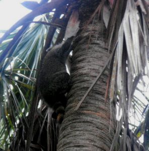
It is no surprise to see raccoons in the day or night, so be sure your food is properly stowed  and your trash is properly disposed of in the receptacles provided. The weighted lids are more than a raccoon can lift to get into the bins, and these are not little raccoons.  The ones strolling through our campsite would easily have weighted 15 pounds.  You’ll also be visited by squirrels and birds, but clearly the largest and boldest of the visitors will be the ring-tailed bandits.   As you can see at the right, they are easily frightened and will scurry away or climb a tree as soon as you get near, however, if you are not around they will go through everything you have that’s not tied down.

Campsites 1 to 48, 138 to 153, and 202 to 232 are all on the water facing generally to the west, although many of these have a hedge of bushes between them and the water, however, a large grassy border extends from the campsites to the water.  It makes a great spot to set up your lawn chair late in the afternoon and watch the sunset.

Sunset at campsite 20

In the picture above, you see the sun setting over the other end of the island, which is L shaped, so on the other side of the trees, the sun is settling into the Gulf fo Mexico just beyond the beach.

As mentioned above, there are no developments on the beach.  However, Fort De Soto was built in the early years after the Spanish-American war between 1900 and 1910 and remains substantially intact.  The fort was rendered obsolete by the development  of mobile modern artillery and so the military closed it between WWI and WWII.  None of the governmental entities nor developers had any interest in the island in the 40’s and 50’s and the island was largely managed as a bird sanctuary.

He owns the Island

Today, thousands of birds can been seen and are still protected on the island, therefore, a large part of the island is off-limits as a nesting area, however, the undeveloped beach is therefore somewhat secluded from the central road and bike path and relatively unspoiled.  The beach is widest and most usable from the Gulf pier (fishing is free with no permit required) up to the bird sanctuary at North Beach and above North Beach to the tip of the island.  The beach extends southward beyond the fort and around the bend in the island past the Bay pier to east beach.  At East Beach and North Beach, parking, pavilions and bath houses are supplied in abundance and are well maintained and clean.  The cycling trail runs the length of the island and connects to a multiuse trail that runs along South Pinellas Bayway for several miles.   You can pedal your hybrid or cruise bike along the path for miles without seeing a hill.  The road cyclist zoom past in their spandex on the road, generally disdaining the multiuse path and its slower traffic.

The island and the campground make up one of the better family camping locales on any beach anywhere.  It’s also quite attractive to the RV crowd.   Camp cleanliness and light maintenance is the responsibility of about 8 couples who serve as camp hosts.  They get their campsite free of charge for three months in exchange for 20 hours per week (per person) spent “doing the chores” that are necessary to keep the camp pristine.  A husband and wife team, who were one of the host couples we spoke with, had been on the waiting list to host at Fort De Soto for three years and were thrilled to have finally arrived for their three month stay.  The Rangers we talked to had all been with the park for at least a dozen years and many of the campers had returned for year after year to the park.  One Pinellas county resident shows up at 2 a.m. on Friday nearly every week to get a walk in campsite so he can spend his weekend fishing and communing with nature.

Arrowhead Picnic Area

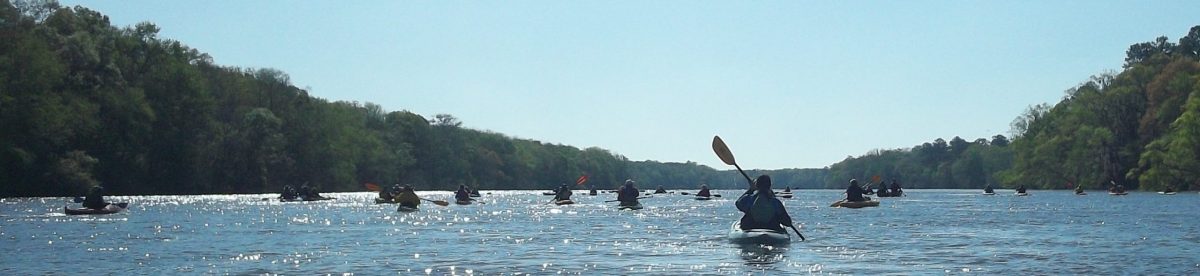
Separate from the campground, on the north end of the island across from the pavilions and bath houses servicing north beach, a narrow road leads to Arrowhead picnic area.  Again, the seclusion and sense of being out in a wilderness is amazing. The area is as well kept as the remainder of the park with trash cans, bath houses, and picnic tables available for day users.  No overnight camping is allowed in this areas.  You may want to just go sit there and rest by the water, or maybe you’ll rent a kayak and paddle up to here on your way to adjacent Shell island, which is also undeveloped and reachable only by boat.  Either way you’ll find it a tranquil and restful spot.

This place is one of our favorite car camping locales.  It’s clear we aren’t alone in thinking this.  One of the rangers told us that about 10 to 15% of the winter visitors are French Canadians.  One couple we met were from California, another from Maine, another lady from Pennsylvania.  There was a good mix of families with kids on bikes, retiree’s in RV’s, couples hanging out together, minding their own business but happy to wave or converse if you wanted.  You can see more about the campground at http://www.pinellascounty.org/park/05_ft_desoto.htm .   There may be additional posts regarding Fort De Soto on Goneguru.com, however, for one last look at the kind of scenery you’ll find at Fort De Soto State Park, here’s a tree that has been there a long, long time.

Inside the campground at Fort De Soto Park.

Smoky Mountains: Hiking Serenity in The Cataloochee

The Great Smoky Mountains National Park didn’t exist before the Great Depression.  Chartered in 1934, the park took in over 800 square miles in eastern Tennessee and western North Carolina.  10 million visitors per year pass through the park, with a large number of them passing along US highway 441 between Gatlinburg, Tennessee and Cherokee, North Carolina.   To the east of this main tourist area, just north of Maggie Valley, NC and just off of I-40 is the Cataloochee.

Settled by white men who gradually displaced the Native Americans between 1800 and the Civil War, the Cataloochee as it is today gives a glimpse of life in the remote valleys of Appalachia at the turn of the twentieth century.  The settlers descendants  were themselves displaced by the creation of the park, leaving behind their houses, barns, fields, churches and cemeteries.  When you go there you will feel the shadows of both the Native Americans and the white settlers, or maybe you’ll just feel the wonderful remoteness and stillness of the place.  Getting there is not difficult, but don’t expect to roll in your RV; you can’t get them around some of the curves in the road.  For an idea of what the road in is  like you might want to take in a video someone posted on You Tube.

The campground is located on the banks of one of the streams flowing through the valley and like most National Park Service campgrounds charges a modest fee for a reservation which can be made online up to 6 months in advance of your trip.  It is perfect for car campers who want to unload their gear from the back of the car onto the picnic table and sort it out from there.  Bathhouses with shower are there, but note that the last time we were there, the filtration system was not working so take along a water purification system or plan to boil all the water you intend to consume.

If you proceed down the road a few yards past the campground, you’ll find the trailhead for the Boogerman loop trail.  The trail climbs the mountain on the side of the valley and comes back down to the stream.  Along the stream you’ll find yourself walking across a dozen or more log bridges.

A typical Cataloochee footbridge

Along this part of the trail, you will share space with horseback riders,  but up on Boogerman loop proper you won’t see any horses.  What you will find are some of the foundations of the houses of the farmers who cleared the fields on these mountains and maybe a little rusted tin from the roof of one or two.  You may even feel as though you are trespassing, walking through a forest regenerated from a field cleared with back-breaking work.  Along the way you will come to a low wall, three to four feet high and three feet wide stretching for a hundred yards into the forest.  Most likely, as the field was cleared and plowed, the rocks in the wall were unearthed and carried to the edge of the field, where they were laid into an orderly wall.  As you can see, in the 85 + years since the Park took over the farms, along these hillsides the forest has  reclaimed fields.

Something in the earth doesn’t like a wall

Look for the giant Poplar tree near the wall.  Its base is hollow and two of us stood inside it.  These giants haven’t been seen by everyone.  I could post a picture, but you need to go see it for yourself.

The trail comes back down the mountain past the old farms and rejoins the stream.  If you went along Boogerman loop clockwise, you’ll turn to the right to get back to the trail head.  As we did so, we soon encountered where the forest had tried to reclaim a footbridge.  We made it across, and as you see it was gracefully done.

Footbridge 8, too far along to go back

Back at the trail head you can turn left and drive  or cycle a few miles down into the valley where the meadows still grow tall grasses. You’ll likely see turkey or deer or, if you are out early in the morning or just at dusk, you may encounter a herd of Elk.  Once native to these mountains, a re-population project was started a few years ago with 25 Elk.  From what we have seen the project has been a success and Elk can be found over a wide area of the National Park.  We intentionally went to the meadow at dusk and were literally surrounded by Elk.  Although they know they have to share the meadow with mankind, they remain nervous creatures, so don’t get too close.  They are wild and deserve their space.


Part of the herd in the meadow by the schoolhouse

If you take the road on down past the bridge and the school-house you’ll come to a farm-house and its barn.  Get out and go into both.  Sense the presence of a time long gone.  It reminded me of my grandparents farmhouse that was built about the same time.  I’ll come back with another post about the houses, barns, churches and schools left behind and the Elk who have returned.

A turn of the 20th century home in Cataloochee


Cycle the MS 150 with Goneguru


We have been very fortunate to have been able to enjoy many great outdoor activities.  In addition to hiking and backpacking, we have participated in the Bike Ride Across Georgia  and numerous other group rides.  They have been great fun and a pleasure to for us. However, there is one cycling experience that we have done several times that is more than just personal fun.  The Multiple Sclerosis Society organizes bike rides at diverse geographic locations that actually help people who suffer from MS by raising money to help find a cure.  To date, I am not aware of a cure but these rides help provide the fund s that keep hope alive.  The rides are called the MS 150 because they entail up to 150 or more miles of riding over a two day period.  Here’s the start.

The Start of our First MS 150

This year Goneguru has formed a team and I am asking you to come ride with us, to enjoy the fellowship and camaradarie, to raise funds for the cure, and to feel better about yourself while doing something for someone you likely will never meet, or perhaps, for someone you already know.  The next few paragraphs will share a little about our experiences and then I’ll give you the link to our team page so you can sign up.  Everyone is welcome, even if you just want to come and camp out with us.

 Our first MS 150 was held at Callaway Gardens in rural Georgia about 65 miles south of Atlanta.  Callaway Gardens is a beautiful sanctuary and worth the visit in and of itself.   The start and finish as well as the food pavilion, bandstand, and camping facilities are all inside the Callaway Gardens property.  Additionally, there are hotels and the nearby Franklin D. Roosevelt State Park campground.  The ride itself consists of two days of riding through the rolling countryside around Callaway Gardens and if you choose the longer route on the first day perhaps over into Alabama.  That route would cover roughly 100 miles.  You can choose shorter routes ranging from about 25 miles to about 65 miles.  The second day is all shouter routes, with none greater than 65 miles.  If you are already a cyclist, these distances don’t phase you.  If you are not yet a cyclist, you have time to get in some “seat time” before the ride this September.  This first ride for us was inspired by people we know with MS.  We joined a small team formed by a person with a family member with MS and wore bandana’s signed by the person.  It was great.  Super weather and  beautiful scenery.

Our next MS 150 was a Spring ride in Savannah, Georgia that took us from downtown Savannah, out to the islands along the coast and back to town.  Unfortunately, a mile into the ride the skys opened up and a torrential downpour soaked the course and everyone on it.  I had failed to clean the pads in my helmet before the ride and the rain water washed salt out of the pads into my eyes just as we were passing one of the squares in Savannah.  The pavement was old and cracked and in  a moment when I tried to wipe my eyes, the front wheel of my bike went into a crack running lengthwise in the road, and cause the real wheels to overtake the front wheels.  This condition leads to an immediate rolling effect for the rider and the bicycle with significant impact onto the roadway.  I damaged some ribs and a shoulder in the fall.  As is my custom, I was riding behind the group, so no one in my party saw me go down although a number of other cyclist had to dodge me and the bike.  I checked the bike, wiped my eyes and got back on.  A couple of miles down the road my party was waiting for me.  We soon found a drugstore where I bought the strongest over the counter pain reliever they had and a souvenier ball cap.  The ball cap went under my helmet to absorb the salt and to this day I wear a cloth ball cap under my helmet every time I ride.  It prevents salt blindness and on a sunny day it gives me an extra bill for the eyes. 

Our last MS 150 was back at Callaway Gardens and this time we joined an organized team.  We wound up wearing the sponsors jersey and cycling with a mix of the employees, their parents, and their kids. 

Starting an MS 150 at Callaway Gardens

We also cajoled one of our hiking buddies, Mark, into riding with us.  He’s a great rider and hopefully will be along this time.

This year, on September 16 and 17, at Callaway Gardens we are going to do it again. In the words of the MS  Society “By joining [a] team, you will be signing up not just for a great ride, but also for a celebration of the great things we can achieve when working hard for a common cause. Each mile we pedal together brings us that much closer to a world without MS. So please, register online to join me or make a donation.”

What we hope to do with MS is to see the day when the last Finish banner can come down and no one has to live with MS.

Make this sign come down!

  Come ride with us and pedal the future a little closer.  To join the Goneguru team  follow the link http://bikegaa.nationalmssociety.org/site/TR?fr_id=18479&pg=teamlist to  the  list of teams  sign up, pledge to raise $250 dollars for the MS society, ride until September, then come camp and ride with us.

Secluded Beach – Cumberland Island

Although Cumberland Island is a National Seashore, there is no bridge to get there, and we all like it that way.  This treasure is the southernmost barrier island off the coast of Georgia (USA) at the mouth of the St. Mary’s River.  Although inhabited for thousands of years, since the 1970’s most of the island has been under the control of the National Park Service which limits the number of visitors to the island to about 300 per day.   The island is 17 miles long and 3 miles wide, so there is plenty of room to separate yourself from the crowd.  Technically, there are some private landowners remaining on the island who are heir’s of the Carnegie’s and other long gone islanders, whose history is chronicled in the book Strong Women, Wild Horses, among others.  I’ll only touch some of the island history to help you understand the place before you make your visit.

Other than the few private landowners and the Park Service employees, there are no vehicles allowed on the island, thus, for those of us who like hiking in serene silence away from the world, this is one of the places where most of the time you’ll be satisfied with what you hear.  One shell packed road runs the length of the island and the eastern side of the island beaches on the Atlantic Ocean, so the beach is immense and virtually deserted.

Stafford Beach on Cumberland Island

The picture above is of the beach three miles from the ranger station.  You can get there by walking or renting a bicycle and cycling along the road.  Otherwise, you won’t see it.   There are no developments on the beach and access across the dunes to the beach is restricted to a dozen or so well marked lanes.  So, how do you really get to this reclaimed beauty?  Read on.

If you have a private vessel capable of navigating the intercoastal waterway, you can get to Cumberland Island by yourself, but most of us rely on the ferry which is authorized by the NPS to carry visitors from the dock at St. Mary’s, Georgia to Seacamp dock on Cumberland Island.  The ferry runs twice a day, once in the morning and once in the afternoon and takes about 45 minutes to get to make the trip.   Pay attention to  your return trip departure time because, although they count heads on the way to the island, they have no way of knowing how many are supposed to be on the boat on the way to the mainland, therefore, they don’t  try to account for your return.  There are also no provisions available on the island, so take your own water and food or buy some on the ferry.  If you are making a day trip and want to rent a bicycle, you have to do it on the ferry.  If you are staying overnight and want to buy firewood, the only place you can do that is on the ferry.

Once you are on the island, the choices and the distance between choices make the decisions for you.  We wanted to backpack to Stafford Beach and camp at the campsites there.  Another group that ferried over with us had young children and were headed to the campsites at Seacamp.   A young couple on the ferry were backpacking a couple of miles beyond Stafford Beach and camping  at an even more remote backcountry campsite.  As you

Boardwalk over the dunes to the beach at Seacamp.

guess, each option had its advantages and drawbacks.   Seacamp is the closest to the dock and ranger station and about 1/2 mile along a sandy trail across the island.  A number of campsites are arranged for substantial privacy and the campsite has running water, showers, toilet facilities and a group area.  The boardwalk shown above leads from Seacamp over to the beach.  You will have miles of beach in either direction, but you will be sharing it with the largest concentration of people on the island.  Stafford beach is 3 and 1/2 miles from the dock along the parallel trail which is well-marked.

Parallel Trail to Stafford Beach

The trail more or less parallels the road, but is a far more enjoyable and easier hike. The trail cuts through the palmetto fronds beneath the live oaks and you soon lose sight of the road  or where you came from.  Watch your step because wild horses and wild hogs share the trails with you and leave their souvenirs along the way.  As plentiful as the dung was, we never saw the hogs, although the population is such that the NPS has had to institute hunts to thin the herd.  The twisted shapes of the live oak trees, the leaves filtering the sun and the limited distance visibility give the landscape along the trail a mystical and unreal quality.  You would not be in the least surprised  to see any creature from folklore stick his head around a tree and look at you .  In all likelihood, you will see the wild horses on the island.  They run free on the island at the command of Ms. Lucy Carnegie, grand dame and matriarch of the island’s Carnegie clan, as set forth in her will decades ago. At the time of the American Revolution, the live oaks were harvested for use in the sailing vessels of the day because of their great strength and resiliency.  Barrier island oak was used in the USS Constitution  and can be seen today if you visit the ship in Boston.

When you arrive at Stafford Beach camp, you can select from one of less than 20 campsites equipped  with a fire ring.  There is a common bathhouse with a cold water shower and toilets, however, any water from the area including the bath house has to be treated by boiling, filtering or chemicals before it can be consumed.  Don’ t even brush your teeth with untreated water.  Your campsite can range from extremely private to rather private depending on the proximity to the bathhouse.  A trail runs across the dunes  to the beach pictured at the top of the post.  Although the rangers sometimes drive over to check on things, the only other  people you will see on this beach are the ones who have hiked three plus miles to get there.  They are there for the same reason you are: and that is nobody’s business.

Stafford Beach campsite

We chose a campsite away from the bath house and away from the beach.  As you can see it was great.  We used the overhanging trees to suspend our supplies so the raccoons, squirrels and hogs couldn’t get into it.  Note that firewood is scarce and you may want to bring a lightweight cutting implement to reduce what you may find to fit into the fire-ring. The campsites north of Stafford Beach are primitive.  There are no bathouses and no potable water.   These campsites are also not near the beach and at least one is on the intercoastal waterway side of the island.  We haven’t made it to one of those yet, but the young couple we met came back smiling.

If you want to see the island and its history in a short amount of time, then you should take the tour.  Fifteen passenger vans leave from the ranger station at the dock twice a day to take you on the tour.  We walked the three and 1/2 miles back to the ranger station one morning to take the tour, only to learn that you have to by the tickets for the tour on the mainland before you get to the island.  Be prepared.  We walked the 7 & 1/2 half miles to Plum Orchard mansion, one of the many Carnegie  mansions on the island and then the 4 miles back to Stafford Beach.  It was worth the walk.  A volunteer working in conjunction with the Park Service was at the mansion and gave us a great talk as he showed us around.   A half mile or so south of the ranger station is the museum, housed in the Carnegie ice house and beyond that are the ruins of the main Carnegie complex, where Ms. Lucy held sway and before her the earlier claimants on this amazing island.  Ms. Lucy’s Dungeness burned in the middle of the twentieth century but you can still sense its grandeur from the ruins.

Dungeness Ruins on Cumberland Island

At the north end of the island is the church where John F. Kennedy, Jr. got married, in between is the Greyfield Inn run by the Carnegie heirs, cemeteries, wild horses and maybe a few ghosts.  Most of all it is a place to get away from it all.  I’ll have more to say in a later post.

Backpacking Grandview Trail into the Grand Canyon

A backpacker’s life is probably not complete without a trip to the Grand  Canyon.  We decided against Bright Angel Trail which heads down from the south rim a the lodge and main tourist area, but, we didn’t really want to take off into the Canyon alone. The solution was REI.  http://www.rei.com/  We had gotten most of our backpacking gear, technical clothes, backpacks, and cycling supplies from REI so as members we get their promotional mailers and emails.  We were hooked on the 3 day backpacking in the Grand Canyon as soon as we saw it.  REI proovided the tents, food, and two  guides Tom and Todd who met us at the campground at the south rim.  After dividing the gear to be carried and assigning us tents, they prepared the first of our amazing meals and told us to hit the sack because we were starting down early the next day. 

And so we did, heading off into the Canyon at Grandview  point down the Grandview trail.  The first few miles were a continuous downhill with switch backs, amazing views and incessant chatter from the excitement.  The first goal was Horseshoe Mesa that we were looking down on and as an added bonus, a cave in the side of the mesa.  We reached the Mesa in a few hours and numerous cut backs.  The trail further down into the the Grand Canyon passes the remnants of a house and storage area and bears off to the east.  A less distinct trail heads off to the west then turns south down to the edge of the mesa.  A narrow trail leads around to a shelf where double entrances to the cave are set back from the cliff face.  Inside the cave is a log, presumably so that if you don’t come back to the entrance, they’ll at least know where you wound up.  Leaving the cave, we headed back across Horsehoe Mesa and drop down 800 feet through the Redwall Limestone.  Well,  it feels like you are going to drop. The problem is your backpack rubs against the wall and urges toward the  empty air that is only inches away from where your feet are trying to land.  Don’t let anybody tell you going uphill is harder.  Going down a trail like this is far more exhausting.

Goneguru’s Travel and Recreation Blog

I’m the Traveler at Goneguru.com. My wife is the Seer.  Together and separately we have had the great good fortune to have hiked, biked, run, traveled and enjoyed such places and things as: backpacking in the Grand Canyon, the White Mountains, Cumberland Island; hiking along the Appalachian Trail, along the Highline in Glacier National Park, to the top of Mount LeConte in Tennessee, and along the coast from Villa Jovis to Marina Piccolo on the Isle of Capri. One or both of us have traveled to Rome, Venice, Florence, Gibraltar, Madrid the Coast of Spain, Costa Rica, the Riviera Maya, San Diego to Maine, and Alaska to St. Thomas.  We’ve swam with Pirranha’s, snorkeled on Caribbean reefs, and ridden our bicycles from border to border.  We’ve done tri-athlons, du-athalons, half-marathons and the Peachtree Road Race.  All of this requires a great appreciation and love of food and travel and most of all meeting people. We intend to recreate our travels for our readers, to share our experiences from the past and future, and hopefully meet up with you along the way.